In order to mitigate that risk, inherent to option agreements, TomaGold has partnered with an experienced gold explorer and involved themselves directly with the exploration work.
[box type=”info” align=”aligncenter” ]Disclaimer: This is an editorial review of a public mining company press release and is not an endorsement. It may include opinions or points of view that may not be shared by the companies mentioned in the release. The editorial comments are highlighted so as to be easily separated from the release text and portions of the release not affecting this review may be deleted. Read more at How to Use this Site.[/box]
TORONTO, ONTARIO–(Marketwired – Aug. 20, 2014) – TomaGold Corporation (TSX VENTURE:LOT) – IAMGOLD Corporation(“IAMGOLD” or the “Company”) today provided an update from its ongoing exploration program at its newly optioned Monster Lake project located 50 kilometres southwest of Chibougamau, Quebec, Canada.
IAMGOLD initiated the current exploration program on the project at the end of 2013 pursuant to an Earn-In Agreement finalized with TomaGold Corporation, in which IAMGOLD may earn a 50% interest in each of the Monster Lake, Winchester and Lac à l’eau jaune properties, collectively referred to as the Monster Lake Project. To earn its interest IAMGOLD must complete scheduled cash payments and exploration expenditures totaling US$17.6 million over five years.
[box type=”note” align=”aligncenter” ]After the global recession hit in 2008, many junior companies sought out new business ventures. TomaGold began as Carbon2Green in 2009 and the company was created to help finance, develop and implement projects that aided in the reduction of greenhouse gases. In December 2011, Carbon2Green acquired the Monster Lake properties located in Quebec, Canada from Stellar Pacific Ventures. Carbon2Green was no longer and in 2012 the company switched gears to mineral exploration.
In November 2013, IAMGOLD optioned the property in a deal that could potentially see them earn 50% interest in the Monster Lake project. IAMGOLD has agreed to spend $16 million in exploration along and pay TomaGold annual cash payments totalling $1.75 million until 2018. We last talked about this property in February when work first began. This release is an update of the current surface exploration program and the final results from its first phase of drilling on the Monster Lake project which is operated by IAMGOLD along with some TomaGold personnel.
With option agreements such as this, it would seem that the property owner has nothing to and everything to gain. But there’s a catch. If the optioning company gets initially poor results or mismanages the project, the property owner can be left with a useless chunk of land that’s near impossible to market to others or advance further. Meanwhile the optioner can move on to the next project and try again. In order to mitigate that risk, TomaGold has partnered with an experienced gold explorer and involved themselves directly with the exploration work.
[/box]
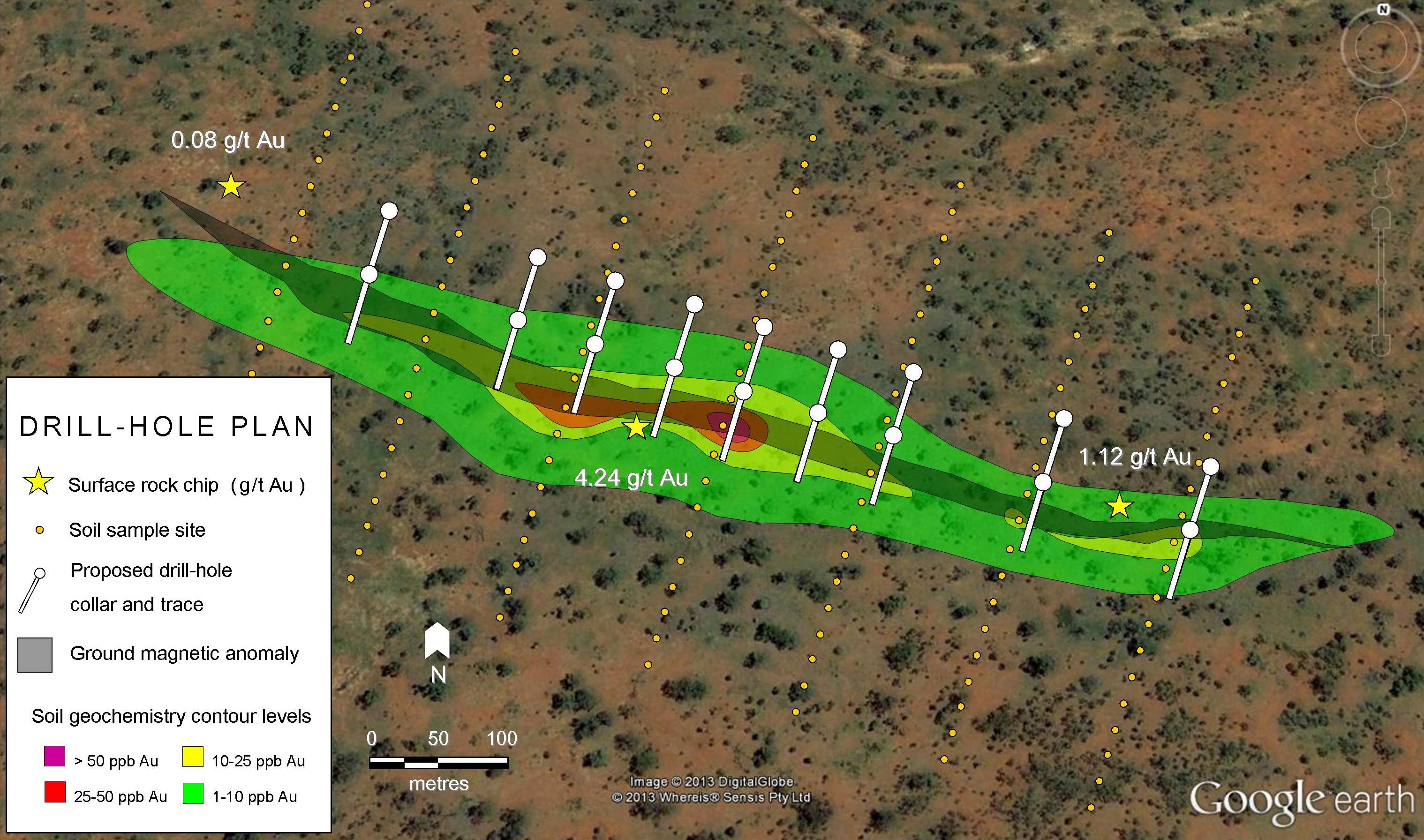
As previously reported in a news release dated May 27, 2014, the Company had completed a phase one diamond drilling program totaling 4,528 metres (nine holes) targeting mainly the direct down-dip and lateral extensions of the 325-Megane mineralized zone previously drilled by TomaGold. All assay results have now been received and validated for the entire phase one drilling program and are provided in Table I below.
Highlights from the last four holes of the phase one program include:
- 2.12 metres grading 2.30 g/t Au from 422.50 metres depth and 5.86 metres grading 2.62 g/t Au from 426.10 metres depth (including 2.21 metres grading 6.21 g/t Au from 426.94 metres) in hole ML-14-115 (325-Megane Zone),
- 3.15 metres grading 2.42 g/t Au from 278.07 metres depth in hole ML-14-116 (325-Megane Zone)
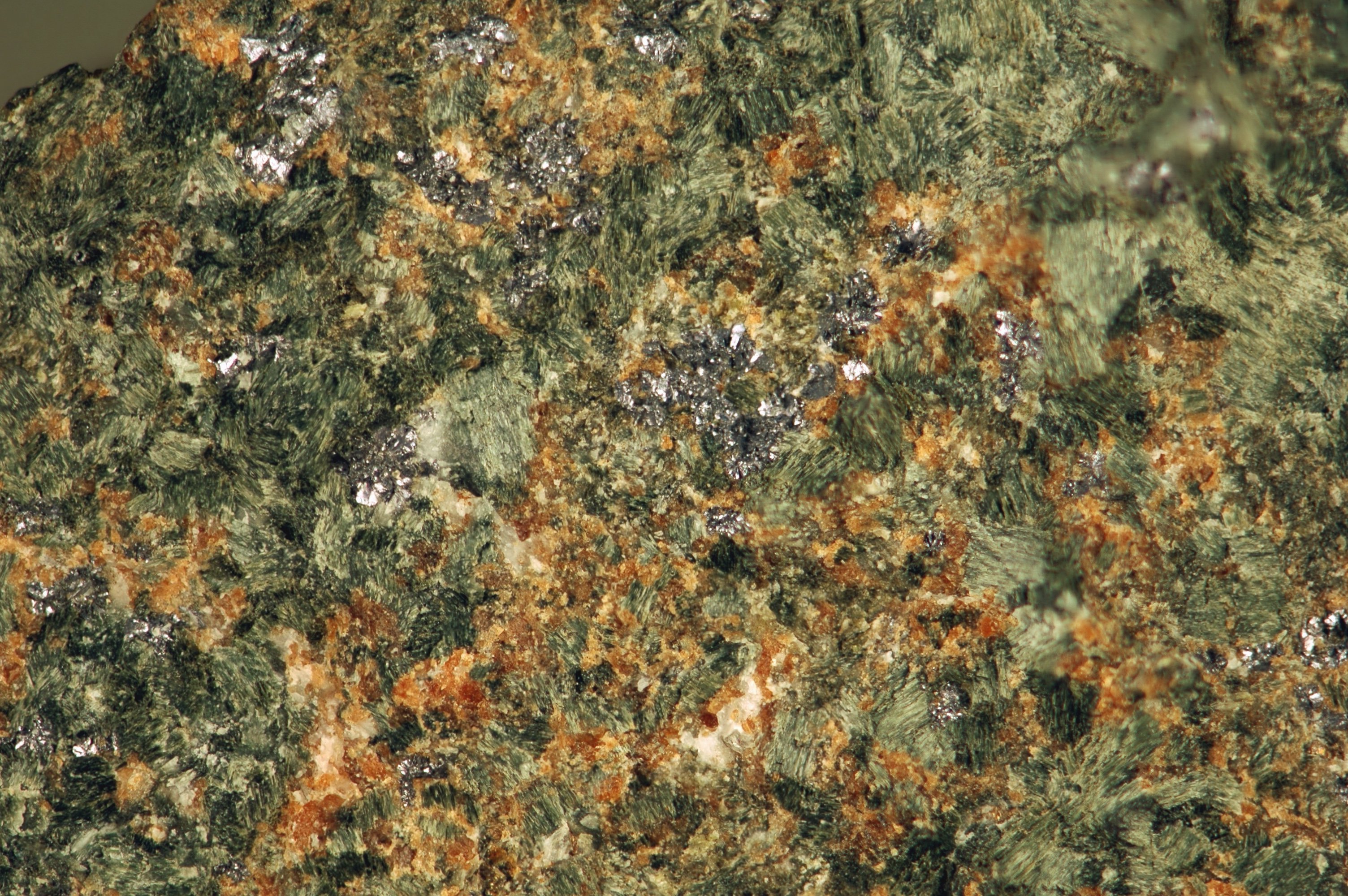
The phase one program has provided encouraging results as it expanded the 325-Megane Zone and identified two additional mineralized zones: the Upper 325-Megane Zone, a newly intersected zone, and the Lower 325-Megane Zone which was tested only in a few areas by previous drilling. The three zones appear sub-parallel and are spaced approximately 100 to 400 metres apart. Initial results reported last May also included: 10.47 metres grading 11.55 g/t Au from 457.0 metres depth (including 48.90 g/t Au over 2.0 metres) in hole ML-14-108 (325-Megane Zone), and an intersection of a footwall zone referred to as the Lower 325-Megane Zone and grading 13.65 g/t Au over 3.77 metres from 636.86m depth, including 46.0 g/t Au over 1.08 metres in hole ML-14-110. The newly discovered Upper 325-Megane Zone is systematically anomalous in gold where intersected to date.
| Monster Lake Project Drilling Final Results – 2014 Winter Drilling program |
| Hole No. | UTMNAD83Zone18(1) | AZ | DIP | EOH | From | To | Interval | True Width(2) | Au | NOTE | |||
| Easting | Northing | Elevation | (m) | (m) | (m) | (m) | (m) | (g/t) | |||||
| ML-14-108 | 520296 | 5488383 | 370 | 290 | -55 | 480 | 56.1 | 58 | 1.9 | 1.65 | 1.81 | Upper 325-Megane Zone | |
| 445.25 | 446.5 | 1.25 | 1.08 | 6.44 | |||||||||
| 457 | 467.47 | 10.47 | 9.07 | 11.55 | 325-Megane Zone | ||||||||
| Including(3) | 458 | 460 | 2 | 1.73 | 48.9 | ||||||||
| Including(3) | 466 | 467.47 | 1.47 | 1.27 | 11.1 | ||||||||
| ML-14-109 | 520316 | 5488270 | 370 | 290 | -55 | 582 | 66 | 71.16 | 5.16 | 4.47 | 1.3 | Upper 325-Megane Zone | |
| Including(3) | 69 | 71.16 | 2.16 | 1.87 | 1.64 | Upper 325-Megane Zone | |||||||
| 559.77 | 560.41 | 0.64 | 0.55 | 0.95 | 325-Megane Zone | ||||||||
| ML-14-110 | 520302 | 5488169 | 370 | 290 | -50 | 667 | 210.1 | 211.26 | 1.16 | 1.00 | 1.04 | ||
| 508 | 509.45 | 1.45 | 1.26 | 0.71 | 325-Megane Zone | ||||||||
| 636.86 | 640.63 | 3.77 | 3.26 | 13.65 | Lower 325-Megane Zone | ||||||||
| Including(3) | 638.8 | 639.88 | 1.08 | 0.94 | 46.17 | ||||||||
| ML-14-111 | 520318 | 5488324 | 370 | 290 | -60 | 454 | 59.59 | 60.13 | 0.54 | 0.47 | 3.48 | Upper 325-Megane Zone | |
| 300.92 | 301.92 | 1 | 0.87 | 1.4 | 325-Megane Zone | ||||||||
| 420.18 | 421.16 | 0.98 | 0.85 | 1.85 | Lower 325-Megane Zone | ||||||||
| ML-14-112 | 520315 | 5488321 | 370 | 291 | -53 | 652 | 480.9 | 489.27 | 8.37 | 7.25 | 1.32 | 325-Megane Zone | |
| Including(3) | 485.18 | 487.27 | 2.09 | 1.81 | 2.97 | ||||||||
| 596.51 | 597.65 | 1.14 | 1.00 | 1.48 | Lower 325-Megane Zone | ||||||||
| ML-14-113 | 520322 | 5488221 | 370 | 295 | -51 | 550 | 514 | 518.47 | 4.47 | 3.87 | 1.50 | 325-Megane Zone | |
| ML-14-114 | 520195 | 5488592 | 370 | 290 | -60 | 313 | 273.8 | 274.99 | 1.19 | 1.03 | 1.89 | 325-Megane Zone | |
| ML-14-115 | 520296 | 5488383 | 370 | 290 | -50 | 304 | 53.62 | 54.86 | 1.24 | 1.07 | 1.58 | Upper 325-Megane Zone | |
| 422.5 | 424.62 | 2.12 | 1.84 | 2.30 | 325-Megane Zone | ||||||||
| 426.1 | 431.96 | 5.86 | 5.07 | 2.62 | |||||||||
| Including(3) | 426.94 | 429.15 | 2.21 | 1.91 | 6.21 | ||||||||
| ML-14-116 | 520000 | 5488115 | 370 | 291 | -61 | 451 | 83.92 | 84.46 | 0.54 | 0.47 | 5.84 | Upper 325-Megane Zone | |
| 278.07 | 281.22 | 3.15 | 2.73 | 2.42 | 325-Megane Zone | ||||||||
| Notes: | |
| 1. | Drill hole intercepts are calculated with a lower cut of 0.50 g/t Au and represents the best results associated to the intersected structure. |
| 2. | True widths of intersections are approximately 85-90% of the core interval. |
| 3. | Assays are reported uncut but high grade sub-intervals are highlighted. |
[box type=”note” align=”aligncenter” ]The final drill results for the phase one program show several low to moderate grade intervals along with some “uncut” higher grade intervals. As part of a company’s QA/QC process, unusually high assay grades are capped at a value that prevents the results from being skewed by random statistical outliers. In a “cut” assay, all grades assayed above the cut are assigned a maximum grade. The cap grade can vary based on the deposit type and typical grade. For these results, no cap is defined. In an early stage program such as this, its not unusual to see uncut grades. Once a deposit is more clearly understood, more careful statistical monitoring of results will be required.
It’s also worth noting that drill highlights can often skew the average grade of a larger interval and it’s always worth approaching these results with caution. In an early exploration program. Lastly, note that results only represent the apparent thickness of the mineralization.
[/box]
A summer field program comprised of geologic mapping, aided by a shallow penetrating electromagnetic survey (Beep Mat of GDD Instrumentation Inc.) to detect potentially sub-cropping conductive shear zones, is currently in progress to help delineate structural trends and confirm priority targets in the central core of the Monster Lake property and in the regional extension of the deformation corridor on the Lac à l’eau jaune and Winchester properties. Detailed structural and lithological mapping on well exposed historic gold occurrences will be used to assist the final targeting for the next drill program currently being finalized.
[box type=”note” align=”aligncenter” ]Surface exploration included geologic mapping and a “Beep Mat” survey. The “Beep Mat” is a small geophysical device used to measure electromagnetic and magnetic anomalies within 3 meters of the surface. The device can be useful in detecting conductive bedrock anomalies in areas with overburden (soil and sediment overlying bedrock). By performing this quick low cost survey, the company can effectively plan future work on near surface targets. The purpose of this survey was to detect conductive shear zones. Shear zones are structural corridors that can act as conduits for metal-bearing fluids and potentially host gold mineralization.
We previously talked about Beep Mat surveys when discussing the summer exploration program by Beaufield Resources.[/box]
Craig MacDougall, Senior Vice President, Exploration for IAMGOLD, stated, “Our involvement in the Monster Lake Project was based on the potential to delineate high grade mineralization in a prospective area possibly hosting several gold zones. These first drill results on the 325-Megane Zone are positive and confirmed the presence of several mineralized structures as well as high grades. The ongoing exploration program is progressing well and we look forward to next round of drilling once the targets are finalized.”
The Monster Lake project is underlain by Archean volcanic rocks of the Obatogamau Formation and is traversed by an important deformation corridor and gold-bearing mineralized structures. Historical drilling and recent success by TomaGold have identified at least a four-kilometre long mineralized structure hosting most of the gold surface showings and diamond drilling intersections, including the 325-Megane Zone.
Next Steps
The summer field program continues and is expected to include a limited outcrop stripping and trenching program to expose key areas identified from the ongoing mapping and geophysical surveys. A property scale glacial till sampling survey and some specific ground geophysical surveys are also in progress over selected areas. A second phase of diamond drilling totaling approximately 5,000 metres is scheduled by the end of October 2014 to test selected target areas along the main mineralized corridor and the down plunge of the 325-Megane zone. The first diamond drill rig mobilizes today and the second rig by the end of the week.
[box type=”note” align=”aligncenter” ]Bedrock can be hidden underneath soil, plants, trees and glacial sediment known as till. Outcrop stripping exposes the underlying bedrock through the use of an excavator, bulldozer or manual scraping.
IAMGOLD is also running a till sampling program on the property. The thick blankets of boulders, gravel and sand known as “till” were left over by melting ice age glaciers. As glaciers advanced across the continent they sometimes eroded mineralized bedrock and left trails of ore minerals leading away from the original source. Geologists with knowledge of an area’s glacial history can follow these trails of ore minerals and use them pinpoint the original source. This is sometimes referred to as drift prospecting or till prospecting.
Geologists will be compiling the data collected from this surficial exploration program to aid in refining drill targets for diamond drill hole planning.[/box]
About TomaGold Corporation
[box type=”note” align=”aligncenter” ]TomaGold is currently trading at $0.095, close to its 52-week low of $0.085. [/box]
TomaGold Corporation is a Canadian-based mining exploration company whose primary mission is the acquisition, exploration and development of gold projects in Canada and abroad.
[box type=”success” align=”aligncenter” ]Have a company or release you’d like us to look at? Let us know through our contact page, through Google+, Twitter or Facebook.[/box]