Osisko has been secretive about the exact location of its prospects in the 60-kilometre long Guerrero Gold Belt. Even with this recent press release, Osisko is still playing its cards close.
[box type=”info” align=”aligncenter” ]Disclaimer: This is an editorial review of a public press release and may include opinions or points of view that may not be shared by the owners of geologyforinvestors.com or the companies mentioned in the release. The editorial comments are highlighted so as to be easily separated from the release text. Please view the full release here.[/box]
(Montreal, July 4, 2013) Osisko Mining Corporation (the “Company” or “Osisko”) (OSK: TSX, EWX: Deutsche Boerse) is pleased to present initial results from its greenfields exploration activities in the Guerrero Gold Belt, Mexico.
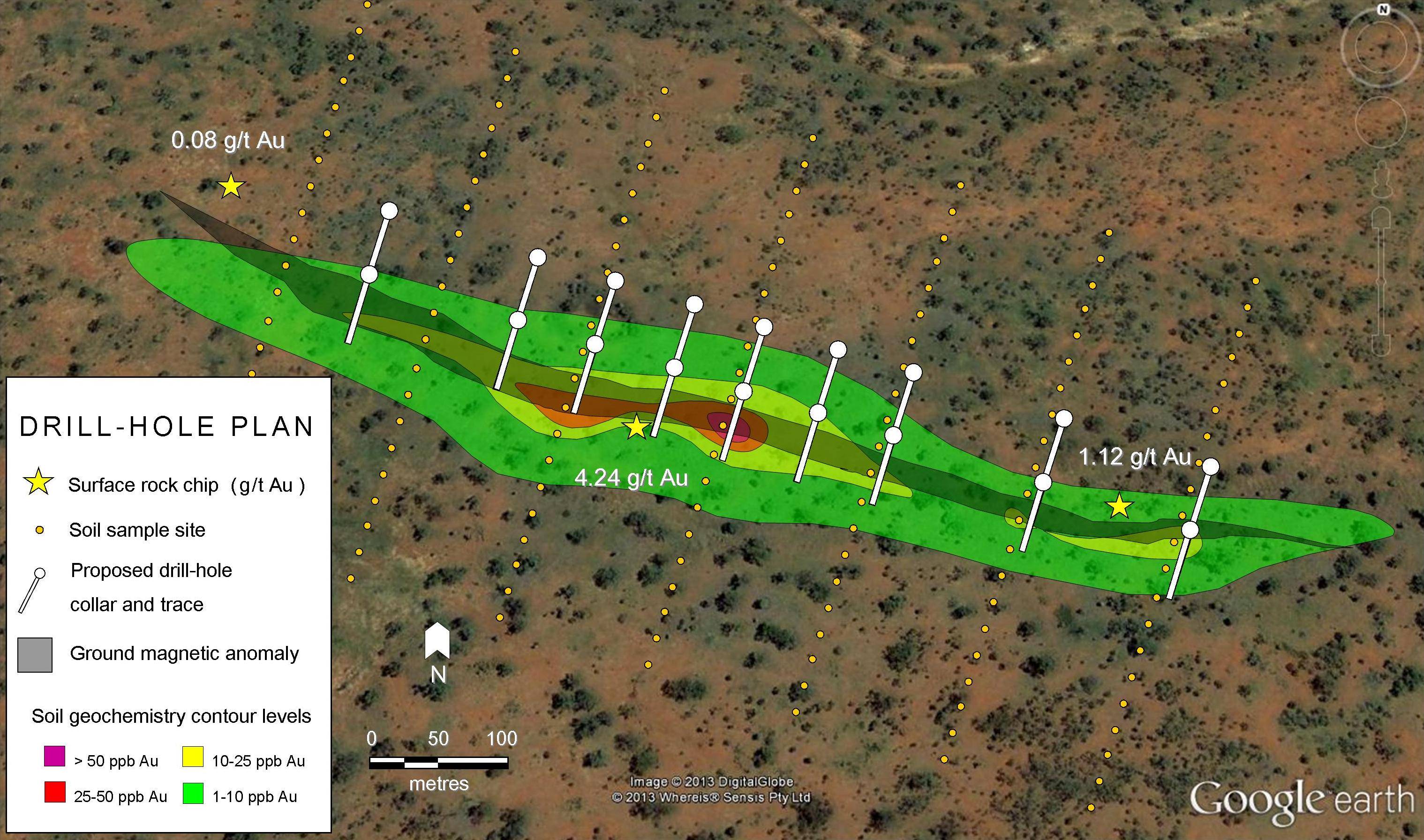
[box type=”note” align=”aligncenter” ] Osisko has been secretive about the exact location of its prospects in the 60-kilometre long Guerrero Gold Belt. It has previously been accused by other analysts of not publishing any location maps and remaining tight-lipped on the exact location of its prospects. Even with this recent press release, Osisko is still playing its cards close to itself. The geochemical map that they have published appears to have only local or truncated coordinates on the axes. Read more about the Guerrero Gold Belt here. [/box]
Highlights:
- Osisko has identified 6 main anomalies which are at or near drill stage, including the Milagro Anomaly, which has a 4 km x 1 km soil and lithogeochemical signature
- 114 targets remain to be reviewed
- 11,870 km2 of Au prospective geology has been covered with approximately 7,700 stream sediment samples as well as 2,800 rock and 3,800 soil samples
- Geophysics completed over 320 km2
- Osisko presently controls 9,600 km2 of mineral rights in Mexico
Cuervo Anomaly
Drilling at Cuervo indicates the presence of Au-Ag-Cu skarn mineralization within a 4km x 2 km corridor. Twenty reconnaissance drill holes were completed in the anomalous area defined by rock and soil geochemistry. Drill results detailed below show significant mineralized intercepts. Subsequent to the preliminary exploratory drilling, mapping and sampling has extended the defined mineralization along strike. Follow-up work on these extensions is planned.
|
Drill Hole ID |
From (m) |
To (m) |
Intercept (m) |
Gold (g/t) |
Ag (g/t) |
Cu (%) |
| EC-017 |
0 |
24 |
24 |
1.26 |
6.0 |
0.23 |
|
36 |
50 |
14 |
0.46 |
4.8 |
0.51 |
|
| EC-016 |
0 |
2 |
2 |
0.23 |
0.7 |
0.02 |
|
10 |
30 |
20 |
0.78 |
10.49 |
0.10 |
|
| EC-015 |
40 |
108 |
68 |
1.26 |
31.5 |
0.53 |
| EC-008 |
0 |
15.95 |
15.95 |
0.68 |
10.4 |
0.07 |
|
22.4 |
33.4 |
11 |
1.03 |
8.23 |
0.30 |
|
|
37.4 |
41.4 |
4 |
1.01 |
5.8 |
0.36 |
|
|
63.45 |
66.75 |
3.3 |
0.35 |
2.24 |
0.08 |
|
| EC-005 |
0.75 |
23.8 |
23.05 |
1.06 |
7.86 |
0.58 |
| EC-004 |
0 |
34.2 |
34.2 |
0.65 |
7.26 |
0.55 |
|
Drill Hole ID |
From (m) |
To (m) |
Intercept (m) |
Gold (g/t) |
Ag (g/t) |
Cu (%) |
| EC-001 |
12.1 |
17.8 |
5.70 |
0.64 |
40.0 |
1.26 |
|
61.5 |
78.3 |
16.8 |
0.13 |
2.0 |
0.09 |
|
|
84.2 |
116 |
31.8 |
0.51 |
6.0 |
0.21 |
[box type=”note” align=”aligncenter” ] Taken at face value these results look encouraging, i.e. wide intersections with reasonable grades. However, these reported drill hole intercepts are apparent thicknesses. Bear this in mind when interpreting the results as the true thicknesses may be significantly different from these apparent thicknesses. We have written an article on the difference between apparent and true thicknesses.
The other thing to consider is the geometry of the skarn mineralization. An understanding of the geometry develops as a drilling program proceeds and knowledge about the deposit matures. Early on in a drill program it is usually difficult to know the size and shape of the zone of mineralization. It is at this stage that any inferences drawn are not taken as the absolute truth. For example, it is quite possible that drill-hole EC-015, the one reported as having an intercept of 68 metres averaging 1.26 g/t Au, 31.5 g/t Ag, 0.5% Cu could have been drilled parallel to the zone of mineralization giving an apparently thick zone.[/box]
Milagro Anomaly
The largest anomaly identified by the stream sediment sampling program is Milagro, where skarn and epithermal mineralization are developed within a 20 km x 10 km area of hydrothermal alteration.
[box type=”note” align=”aligncenter” ] For a brief overview of stream sediment sampling see our article, Geological Field Work – When is it Justified? [/box]
The main target within Milagro is defined by a 4 km x 1 km soil and rock anomaly produced by discontinuous outcrops of gossans developed after the oxidation of magnetite-sulphide bearing skarn. Gold in soil values within this anomalous corridor vary between 50 and 4,800 ppb Au and 0.05% Cu to 1.23% Cu, with a higher grade area of 1 km x 1.2 km with continuous rock values ranging between 500 and 4,800 ppb Au and 0.1% to 1.23% Cu. Rock samples from the discontinuous gossans outcrops present gold values between 50 ppb and 8.2 g/t, with more than 25% of samples with gold values higher than 0.5 g/t. The main target is open to the north, is drill ready and all necessary permits are expected to be received in the second half of 2013.
[box type=”note” align=”aligncenter” ] Keep in mind here that geologists are good at finding mineralized rock when sampling. This is a natural tendency and it is difficult for most people to only sample representative rocks outcropping in an area as they tend to be less interesting. Osisko says the gossan outcrops are discontinuous which might also imply that the mineralisation at depth has no continuity too. For a good summary on soil and rock chip sampling read our article here. [/box]
An additional three target areas are in detailed mapping and sampling phase. Reconnaissance sampling and mapping over the entire Milagro altered area is in progress and additional drill targets are expected to be developed.
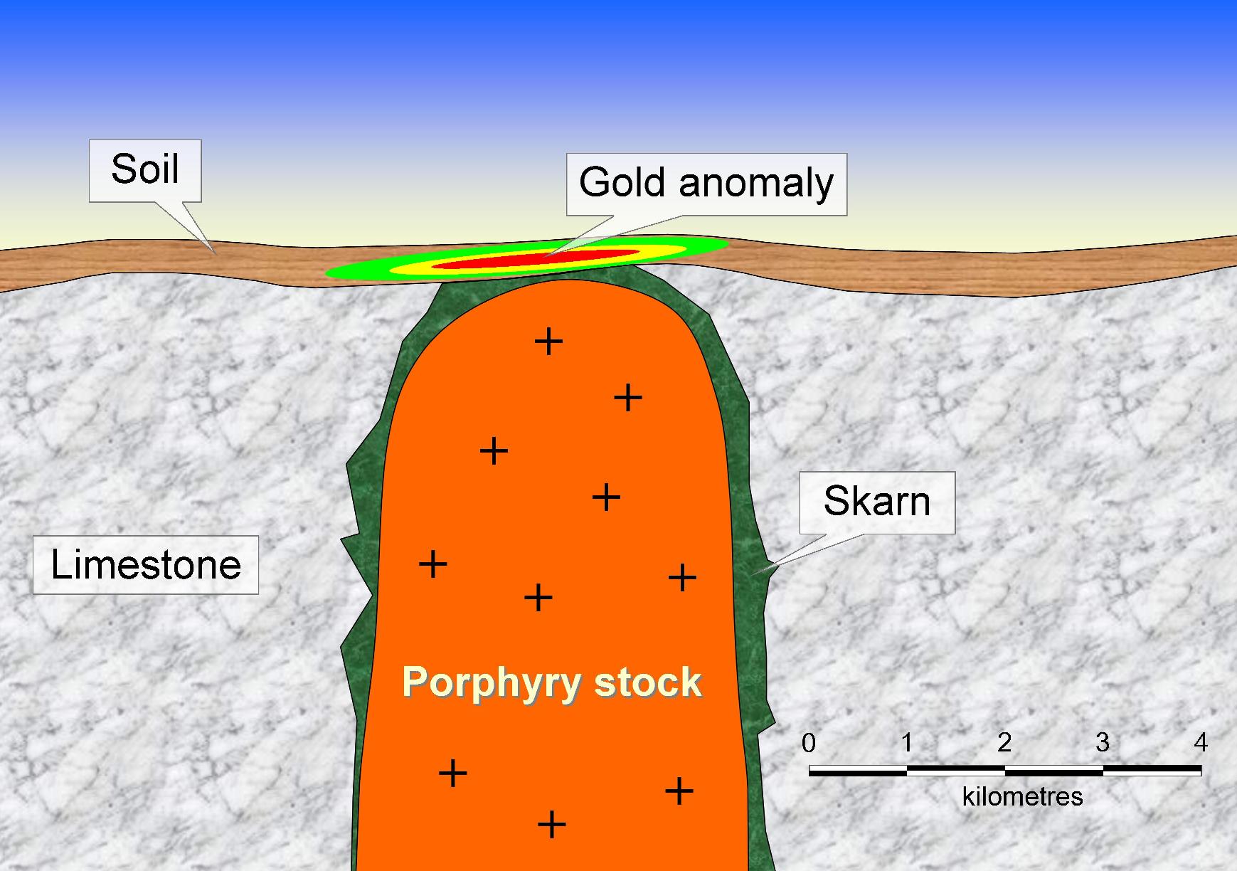
[box type=”note” align=”aligncenter” ] Although the area of mineralization appears large, it may not necessarily have great volume to it. Skarn deposits are developed on the margins of igneous intrusions with carbonate-rich country rocks, however if the geometry is such that the top of porphyry stock is near the surface then the area of gold anomalism would appear quite large. We have created a diagram that shows how this is possible.
[/box]
Quality Control
True widths of reported intervals are interpreted based on drill-hole intercepts and interpreted orientations of intersected lithologies and are estimated at 85-90% of the core length interval.
[box type=”note” align=”aligncenter” ] The words to keep in mind here are “interpreted” and “estimated”. Geologists have exploration models which are continually updated and refined as new data comes in. Wherever you see these words always err on the side of caution as they are used to cover geologists (and the company) when their models are later proved to be wrong. [/box]
Assays are uncut. All HQ core assays reported were obtained by standard 30 g fire-assaying-AA finish at ALS-Chemex Laboratories of Vancouver, BC. Drill program design, Quality Assurance/Quality Control and interpretation of results is performed by qualified persons employing a QA/QC program consistent with NI 43-101 and industry best practices. Standards and blanks are submitted every 25 samples for QA/QC purposes by the Company as well as the lab. Approximately 5% of sample rejects and/or pulps are sent to secondary laboratories for check assaying.
[box type=”note” align=”aligncenter” ] It is good to see that Osisko has a QA/QC program. For more on QA/QC see our article here. [/box]
Mr. Robert Wares, P.Geo. Chief Geologist of Osisko Mining Corporation is the Qualified Person who has reviewed this news release and is responsible for the technical information reported herein, including verification of the data disclosed.
About Osisko Mining Corporation
Osisko Mining Corporation operates the Canadian Malartic Gold mine in Malartic, Québec and is carrying out exploration and project development within the Americas.
[box type=”success” align=”aligncenter” ]Have a company or release you’d like us to look at? Let us know though our contact page, through Google+, Twitter or Facebook.[/box]