Oil and Gas Exploration
Commonly, seismic surveys are used in oil and gas exploration to identify structures and rock layers deep underground. In the industry, this is called seismic stratigraphy. Large hydraulic vibrators or explosions are used to generate the powerful seismic waves needed to penetrate deep underground. Reflections from rock layers are picked up by microphones (geophones) located on the surface. Processing of the data by a geophysicist produces images of the underlying rock strata and structure. Geologists interpret these images to determine where reservoirs and traps for natural gas and petroleum are located.
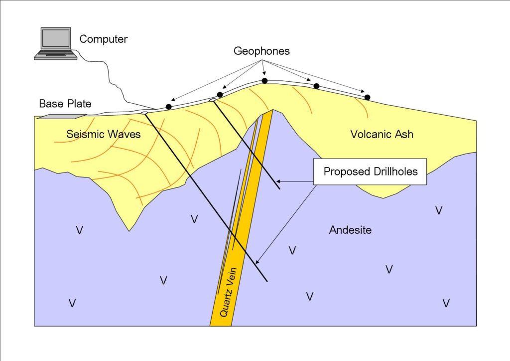
Epithermal Gold Exploration
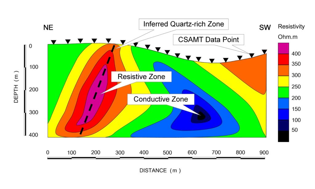
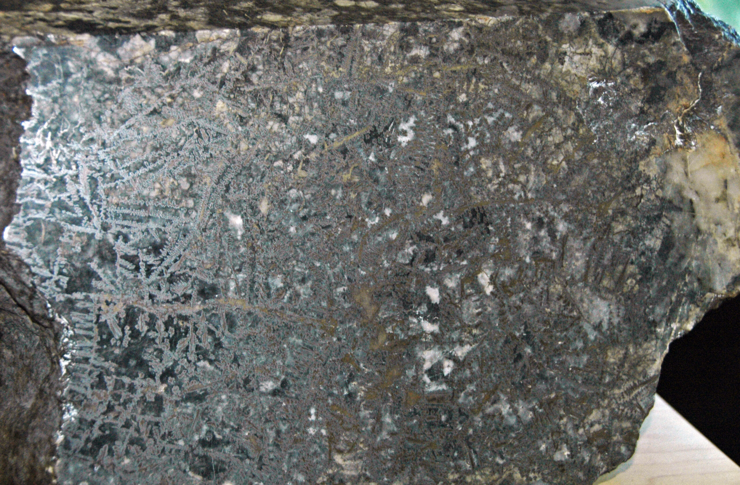
Gold exploration companies also use seismic surveys, although on a smaller scale, when looking for quartz veins hidden under thick layers of soil, sediment and/or volcanic ash. Hydrothermal activity, which is often responsible for gold mineralisation, results in silica-rich zones around quartz veins. This chemical alteration makes the neighbouring rocks harder and therefore more resistant to weathering and erosion. After a long period of exposure, a rugged terrain may form through differential weathering and erosion. Topographic highs revealed by seismic surveys in an ancient buried landscape may point to epithermal quartz veins and other silica-rich zones associated with gold mineralisation.
Seismic surveys are used in the Coromandel region of New Zealand, where epithermal gold mineralisation is hidden under thick volcanic ash layers.
How Is It Done?
A seismic survey requires the planting of a series of geophones into the ground that are connected via a cable to a computer. Another cable runs from a metal base plate several metres from the end of the line of geophones. When the plate is struck with a sledgehammer, shock waves propagate outwards. These waves then interact with the underlying rock layers.. The computer records the delay between when the hammer strikes the plate to when the waves are picked up by the geophones. The longer the delay the deeper is the feature that caused the reflection.
Usually a couple of strikes of the plate are recorded and the results are either averaged or the best shot used during data processing. Different geophones are used for recording different frequencies, each of which corresponds to different depth penetrations. Progressively, the plate and the geophones are moved, in unison, across the landscape. Successive shots and recordings build up a picture of what lies beneath the surface.
A team of people is required to run a seismic survey. Two or three field assistants are on the geophone line, moving cables and planting the geophones. The biggest and strongest assistant usually operates the metal plate and hammer, as the more energy that can put into the ground the deeper the seismic waves can penetrate. When carrying out seismic work, quiet during recording is important, as is avoiding windy days. Wind can generate seismic waves at the base of trees which can interfere with the recordings and generate “noise”. The work usually progresses slowly with much standing around waiting for the geophysicist to give the go ahead to move the base plate and geophones. This is not so much of a problem when working in a beautiful country such as New Zealand with its spectacular scenery. It’s certainly not as good for your fitness as a ground magnetic survey!
Before starting a survey, consultation with the local council is needed to ensure that no noise control regulations are being breached.
Good landholder liaison is required, as the repeated bashing of a metal plate may annoy neighbours. Before starting a survey, the local council needs to be consulted to ensure that no noise control regulations are being breached. This may include restricting the survey to certain times of the day.
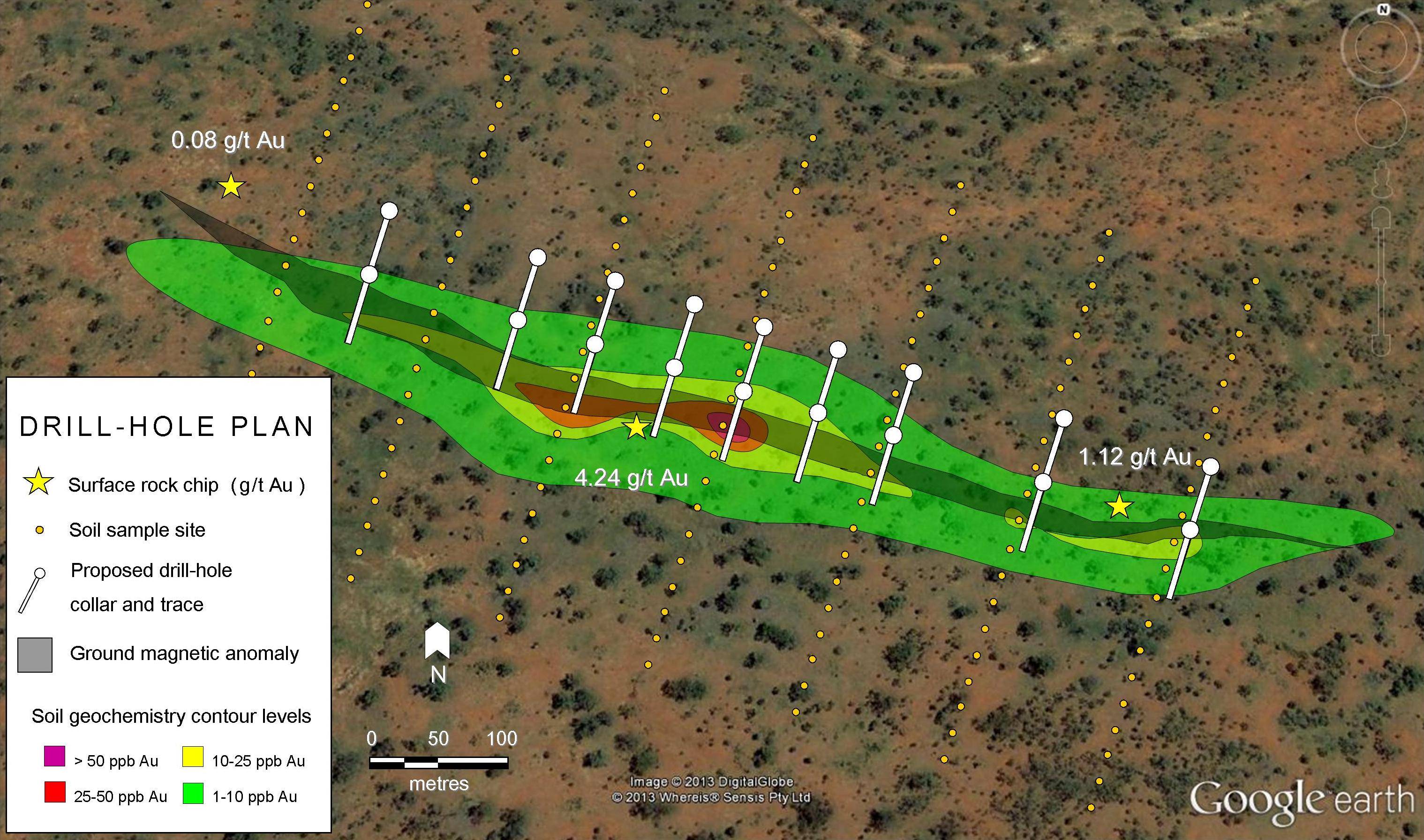
Data Interpretation and Drill Hole Planning
Later, after processing by the geophysicist, the seismic images are interpreted by the geologist who infers the rock type and any geological structures at depth. The geologist then plans the best locations for drill holes to intercept any possibly mineralised zones.
To aid the geologist in drill hole planning other techniques such as rock and soil sampling may be used to confirm the prospect. Geochemistry assay may be used to detect what is known as coincident anomalies: where a seismic anomaly coincides with a geochemical anomaly. When this happens, the evidence for a buried mineralised zone is significantly stronger as is the argument for drilling it.