An extraordinary amount of prospecting and exploration work can be done from behind a desk – and this is especially true for early-stage prospects – but eventually you have to put your money where your mouth is and start ground proofing your theories.
[box type=”info” align=”aligncenter” ]Disclaimer: This is an editorial review of a public mining company press release and is not an endorsement. It may include opinions or points of view that may not be shared by the companies mentioned in the release. The editorial comments are highlighted so as to be easily separated from the release text and portions of the release not affecting this review may be deleted. [/box]
MOUNT PEARL, NEWFOUNDLAND–(Marketwired – Nov. 4, 2014) – Cornerstone Capital Resources Inc. (“Cornerstone” or “the Company”) (TSX VENTURE:CGP) (FRANKFURT:GWN) (BERLIN:GWN) (OTC:CTNXF) announces that it is initiating an exploration program on its Miocene project located in Northern Chile through its Chilean subsidiary Minera Cornerstone Chile Limitada (MCCL).
[box type=”note” align=”aligncenter” ]
We haven’t talked about these guys before, but there’s some interesting exploration concepts in this release that we haven’t previously covered. Cornerstone is a Newfoundland-based junior miner with exploration properties in Ecuador and Chile. The company was initially focused on several exploration projects in Newfoundland, but in 2011 acquired projects in Ecuador and Chile and began shifting their focus in that direction. They currently have 6 properties in Ecuador and 2 in Chile. The Chilean Miocene property is a gold-silver-copper prospect and is the focus of this release.
[/box]
HIGHLIGHTS:
- Regional compilation work completed.
- Review and integration of data from previous surveys and from surrounding properties.
- Definition of large, highly prospective areas for porphyry and epithermal style of mineralization to be systematically explored in the next several months.
“We are very pleased to restart exploration on the Miocene project”, stated Cornerstone’s President & CEO, Brooke Macdonald. “Generative work done by our geologists is very encouraging and discoveries made next door and on strike with our exploration targets by our neighbor Mirasol Resources demonstrate that this underexplored and exciting part of northern Chile has high potential to host a new mineralized district and large deposits”.
[box type=”note” align=”aligncenter” ]
Regional compilation work is essentially background research and doesn’t generally take place in the field. A lot of exploration can be done from behind a desk: Compilation work will often include a broad summary of previous work on a property, regional and local geology. Depending on the location there may be a great deal of information available or there may be very little.
[/box]
Miocene Property
The Miocene project granted concessions cover an area of 152.1 km2 (15,210 hectares) across two contiguous concession blocks in northern Chile. The project spans the boundary between the Antofagasta region (Region II) and the Atacama region (Region III), although it lies mostly within the Atacama region, approximately 250 km southeast of the port city of Antofagasta.
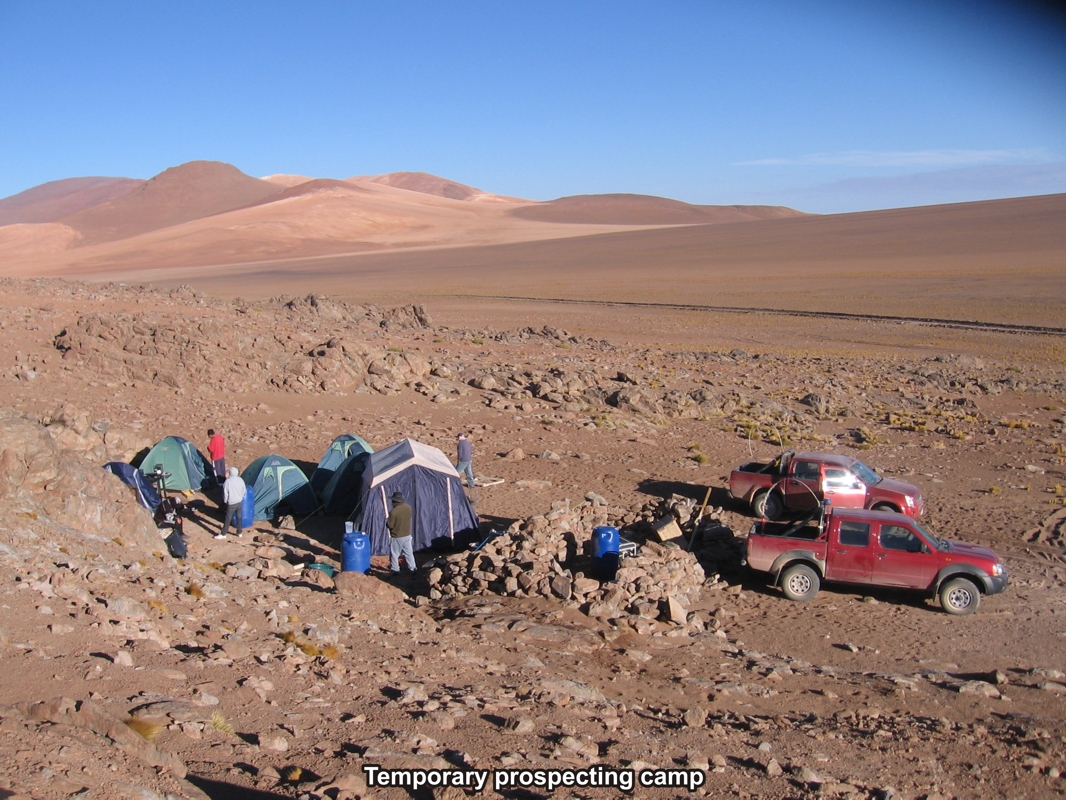
The project area lies at elevations ranging from 3720m on the eastern margin of the concessions to 4845m near the western margin of the concessions on the flank of the Chaco volcano. The terrain is largely denuded of vegetation, typical of high elevation in the Atacama desert.
[box type=”note” align=”aligncenter” ]
The property is at high elevation in a mountainous desert terrain. This photo (below) from the company’s 2011 prospecting work on the property pretty much sums it up. Unfortunately little prospecting work takes place on tropical beaches. Though there are some exceptions.
[/box]
Regional Geology
The Miocene volcanic belt in Chile and Argentina extends from around 24°S to 47°S. In northern Chile the Miocene belt lies along the eastern (inland) side of the Eocene-Oligocene belt. However, the metallogenically productive section of this belt extends from around 25°S to 35°S.
The Miocene volcanic rocks near the northern end of the Miocene belt, between latitudes 26°S and 28°S, comprise the Maricunga belt, a linear belt of volcanic rocks, and a metallogenic unit, that is defined by at least 14 zones of gold and silver mineralization in this latitude interval. This belt is well studied and provides good background to the more extensively covered Miocene sequences further north in the area of Cornerstone’s Miocene project.
The area to the north of the Maricunga Belt is increasingly covered by Late Miocene to Pliocene volcanic sequences and surficial gravel deposits derived from these younger volcanic sequences. Exploration north of the Maricunga belt, between latitudes 25°S to 26°S, has been less intense and less effective due to this Late Miocene and younger cover.
[box type=”note” align=”aligncenter” ]
The Miocene is a geological time period which ranges from 23 to 5 million years ago. This is very young in geological terms: Consider the Archean gold districts we talked about last week which are more than 4 billion years old. The young volcanic mountain belts along the west coast of South America are highly prospective for copper porphyry and epithermal gold deposits related to this “recent” volcanic activity.
[/box]
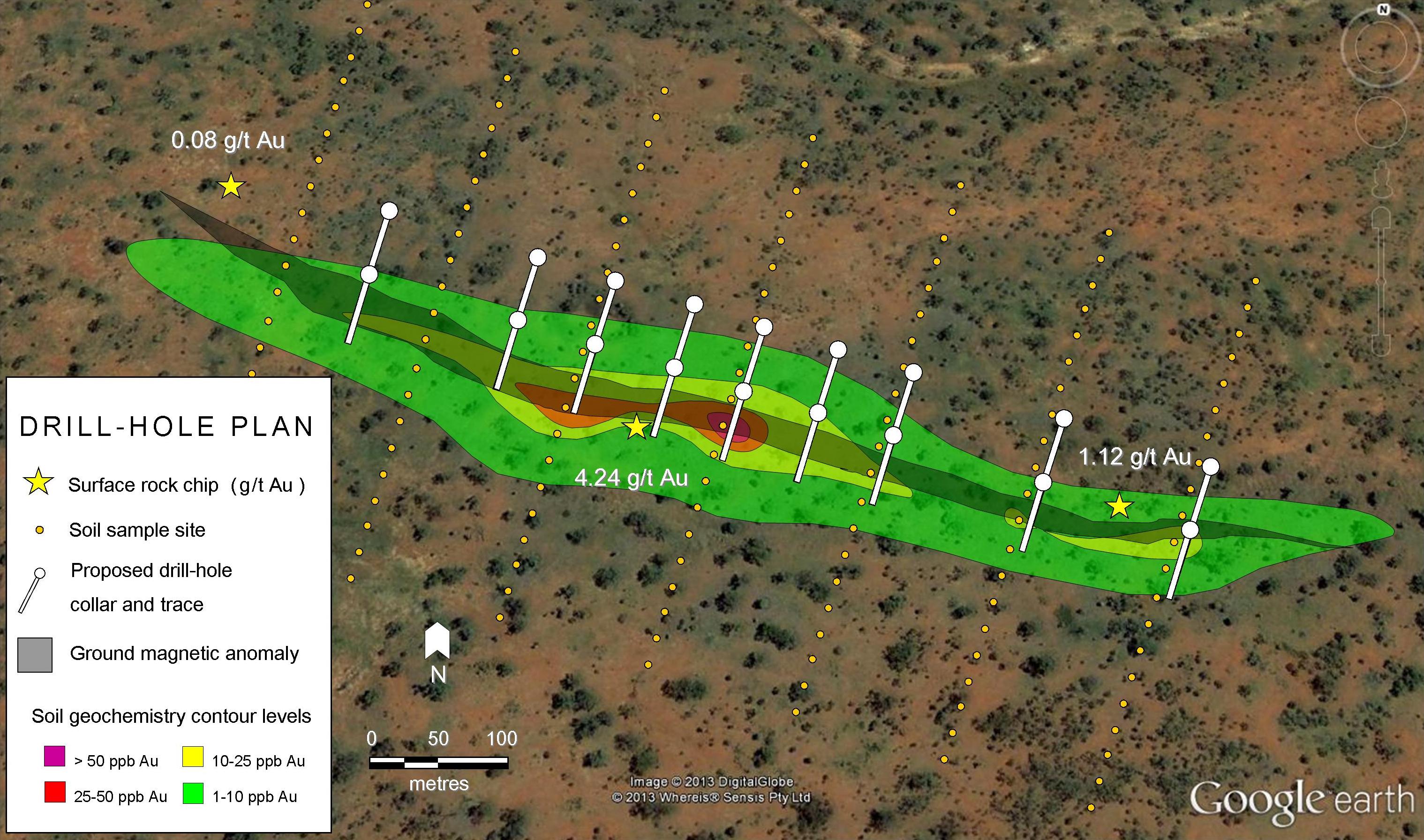
Furthermore, the structural framework in the region supports the prospectivity of this northern extension to the Miocene Belt, as it is transected by NW-SE trending crustal lineaments (Figure 2 and 3). Particularly prospective regions are where these NW-SE trending lineaments intersect the Domeyko Fault Zone, e.g. Oligocene – Chuquicamata, Escondida, El Salvador, Potrerillos; Miocene – Cerro Casale, Pascua Lama, Veladero. The Miocene Project lies at a similar structural setting, where the NW-SE trending Culampaja Fault intersects the Domeyko Fault Zone.
[box type=”note” align=”aligncenter” ]
The map at the top of this page show “topographic lineaments” which follow the regional faults in the area. Identifying topographic lineaments can be as easy as looking at a map or satellite photo, or even Google Earth. Broad structural trends can be identified from satellite photos and good quality air photos can be used to gain highly detailed geologic and geographic information. In fact, geologists will often use duplicate air photos to create stereoscopic 3D images of a terrain in order to identify structural features on a property.
[/box]
Project Geology
The area is underlain by a series of andesitic lava flows and tuffaceous units at the base of the local stratigraphic column (24-20My) and aligned in a NNW direction possibly indicating the general direction of structures controlling the position of volcanic vents (Figure 4).
Around 18-16 My, flows and tuffs of dacitic composition were deposited to the southeast at about the same time than the ignimbrites of the Rio Frio Formation. Towards the end of the period, andesitic to rhyolitic volcanic and pyroclatics units were deposited at Cerro Chaco and Cerro Blanco.
The volcanic activity followed during the period 13 My to 11 My with the deposition of ash and lapilli tuffs part of the Plato Superior Formation in the Llano Blanco valley and Salar Agua Amarga areas and andesitic lava flows at Cerro de Azufre.
Quaternary age gravels derived from these volcanic units occupy lower ground as a thin veneer over large areas and some depressions. These non-consolidated units have been divided into 3 units to better characterize the soil geochemical anomalies: containing hydrothermally altered clasts, containing colloform silica clasts and, containing unaltered clasts.
The older sequences (24-16Ma) are broadly confined to a subtle structural depression (~6 km wide) that trends northwest-southeast, while the younger sequences (16-11 Ma) tend to occur on the northeast and southwest side of this depression. Most of the mapped alteration is confined to this structural depression where it appears to primarily affect the oldest andesite sequence.
[box type=”note” align=”aligncenter” ]
The company describes several types of volcanic rocks found on the property. Mapping of these units may help them determine the relationship between the various periods of volcanic activity and ultimately lead them towards the rocks that are most prospective for their target commodities. The company has also mapped the areas covered by surface gravels and attempted to sub-categorize these gravels. This may help lead them to hydrothermally altered bedrock that may be associated with a epithermal vein system or subsurface porphyry copper system. Or it may not.
[/box]
Previous Exploration Conducted by MCCL
Initial exploration activity conducted by MCCL involved acquisition and processing of Landsat and ASTER (Advanced Spaceborne Thermal Emission and Reflectance Radiometer) satellite imagery data defining a series of anomalies across a broad region of the Miocene Project, some of which lie beyond the current outline of the Miocene property.
[box type=”note” align=”aligncenter” ]
This describes the satellite photos that the company examined as part of their mapping process. Highly quality satellite photos are available from commercial sources and are often used in exploration.
[/box]
MCCL undertook reconnaissance geological mapping across the entire Project area. The mapping revealed a detailed volcanic stratigraphy within the region and also identified the distribution of hydrothermally altered bedrock in areas where it was exposed, or not covered by surficial gravel (Figures 4 and 5).
[box type=”note” align=”aligncenter” ]
“Reconnaissance geological mapping” is large scale, low detail mapping that is the geological equivalent of going for a long walk and looking around. It’s a typical first step for field work. Prospective sites with interesting rocks are typically flagged for follow-up and examination in more detail.
[/box]
MCCL covered the entire concession area with a relatively open soil sampling grid of 1 km spaced lines, with sample spacing along the lines alternating between 250m and 500m spacing and collected scattered rock-chip sampling over and beyond the concession area. Soil samples were analyzed utilizing a combination of analytical techniques (partial and total digestion) designed to detect deep and/or buried mineralization.
[box type=”note” align=”aligncenter” ]
The sample grid is also very low resolution, but it’s a start. Getting rocks and soil samples from throughout the property helps build a reference library for mapping the various rock units and may help identify prospective areas for follow-up work. They don’t say what type of analysis was used test for “deep mineralization” or what the results were.
[/box]
Exploration data generated by MCCL and other exploration companies working in the same district was compiled and integrated within a regional database including airborne magnetic data. Metallotects and several large (several km) and highly prospective areas were defined on strike with mineralized prospects recently discovered on neighboring ground. A follow up exploration program has been designed to evaluate anomalous zones defined by previous surveys and new targets defined by compilation work.
[box type=”note” align=”aligncenter” ]
Many governments will run geophysical surveys of large areas in order to encourage exploration in an area. It looks like Cornerstone had access to data from a regional airborne magnetic survey.
[/box]
Follow up exploration program
A systematic prospecting program has been designed to cover anomalous precious, base metals and pathfinder elements associated to porphyry and epithermal style of mineralization from previous surveys. Field crews will be initiating exploration work the first week of November. A ground magnetic survey and an Induced Polarization (IP) survey will be carried out as a second phase over the most prospective parts of the property, followed by trenching and, if time permits, drilling of targets developed during this proposed exploration program.
[box type=”note” align=”aligncenter” ]
The company intends to follow-up with ground magnetics and an IP survey. Both of these surveys can be useful in detecting dispersed metal sulfides minerals similar to what one might find in a copper porphyry. Trenching and drilling may be performed on the most prospective zones.
[/box]
Qualified Person:
Yvan Crepeau, MBA, P.Geo., Cornerstone’s Vice President, Exploration and a qualified person in accordance with National Instrument 43-101, is responsible for supervising the exploration program at the Miocene project for Cornerstone and has reviewed and approved the information contained in this news release.
About Cornerstone:
Cornerstone Capital Resources Inc. is a well-funded mineral exploration company based in Mount Pearl, Newfoundland and Labrador, Canada, with a diversified portfolio of projects in Ecuador and Chile, and a strong technical team that has proven its ability to identify, acquire and advance properties of merit. The company’s business model is based on generating exploration projects whose subsequent development is funded primarily through partnerships. Commitments from partners constitute significant validation of the strength of Cornerstone’s projects.
Further information is available on Cornerstone’s website: www.cornerstoneresources.com and on Twitter.
[box type=”note” align=”aligncenter” ]
Cornerstone hasn’t put a lot of resources into the Miocene prospect aside from their initial prospecting trip in 2011, but it looks like someone in their office has been doing fair bit of research and planning in order to restart the exploration process. An extraordinary amount of prospecting and exploration work can be done from behind a desk – and this is especially true for early-stage prospects – but eventually you have to put your money where your mouth is and start ground proofing your theories. Hopefully no one has moved on to that sweet rock pile where they set up camp last time.
Cornerstone’s stock is relatively inactive and sitting at $0.05. Like most juniors, it’s currently at a one year low off from it’s high of $0.24 reached in February 2014.
[/box]
[box type=”success” align=”aligncenter” ]Have a company or release you’d like us to look at? Let us know though our contact page, through Google+, Twitter or Facebook.[/box]