
There’s something about diamond exploration that gets people excited. Maybe it has something to do with the visuals. The value of a gold deposit can often only be viewed in the results of geochemical report or as the occasional yellow smudge on a piece of rock, whereas a fortune in glittering diamonds can be held in the hand. While a gold deposit is often the result of a series of long-lived geologic processes, diamonds are deposited near the surface of the earth through violent deep-sourced volcanic eruptions. For investors, diamond exploration projects are highly speculative and expensive long term undertakings. Yet the rewards, if realized, can be huge.
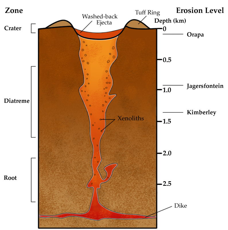
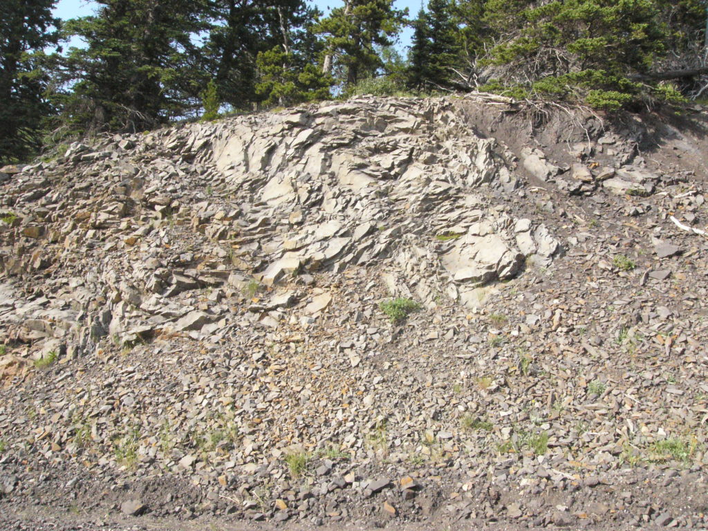
The process of exploring for diamonds is actually exploration for the host rock that carried the diamonds to the surface – kimberlite. Kimberlite is a volcanic rock that occurs in diatremes, or narrow volcanic “pipes”. It may also occur in vertically oriented narrow sheets, or dikes. Once a kimberlite is found there is no guarantee that economic grades of diamonds, or any diamonds at all will be found, but it’s a good start.
Diamond exploration may be broken down into three general stages: Early Exploration, Targeting, and Evaluation. When each stage is successful, the end result is generally a pre-feasibility study which outlines, in considerable detail, the design of the mine together with the sequence of ore extraction. Pre-feasibility studies consider the optimization of cash flows over the life of the mine. Of course, there’s a long way between early exploration and potential mine feasibility. Let’s start from the beginning.
Stage 1: Early Exploration
Narrowing the Field
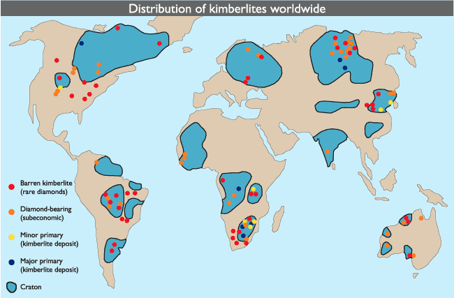
While many companies may already have an idea of where they’d like to look for diamond-bearing kimberlites, large miners may start with a broad global targeting plan, whereby areas of the world are prioritised as likely settings for the emplacement of kimberlite pipes. The most likely settings for kimberlite emplacement are Cratons; the oldest, and most deeply rooted rock formations that make up the stable cores of the continents. They have undergone relatively little structural change over hundreds of millions up to 4 billion years and are generally the thickest parts of the Earth’s lithosphere (crust + upper mantle).
This is important when you consider the shape of a kimberlite pipe: If the host rock has undergone a lot of warping the integrity of the pipe will be lost. Kimberlite pipes are often only a few hundred meters across so from a geologic standpoint it wouldn’t take much to completely obliterate it. On the other hand, the long term stability of cratons allows the narrow pipe geometry to remain intact.
In some areas, the craton may be exposed at the surface (e.g. the Canadian Shield) while in others it will reside under thick cover of loose sediments and sedimentary rock. Academic and/or government funded regional scale geochemical and geophysical studies can help define these areas in unexplored or underexplored regions.
(From the MINEX Exploration Newsletter No. 22 originally adapted from Geology of Canadian mineral deposit types O.R. Eckstrand et al, 1995, Geology of Canada No. 8, Geological Survey of Canada.)
Reconnaissance sampling
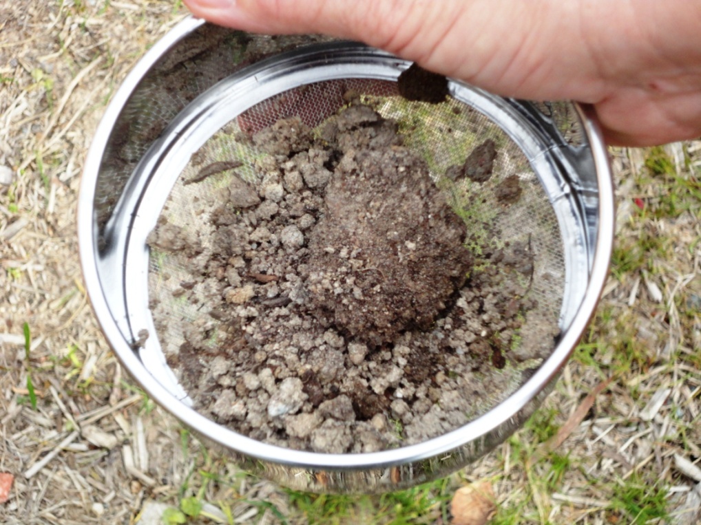
In glaciated terrains, reconnaissance sampling of glacial sediments is done on a wide regional scale to look for kimberlite indicator minerals (KIMs). This type of sampling is done on a kilometre-scale basis across tens to hundreds of kilometres. KIMs are particular minerals associated with kimberlite intrusions; kimberlites act as transport mechanisms for minerals that only exist at depth within the Earth. Garnet and ilmenite are two examples of KIMs and specific types of garnets can help geologists and geochemists establish the kimberlite petrogenesis (i.e. where it came from). If KIMs are found in the samples, the next step is to go in the “upstream” direction back towards the source of these indicators. In many cases regional data may already be available for interpretation from government or other company databases. For example, consider this excerpt from a Peregrine Diamonds news release we recently reviewed:
“… A key asset being utilized in Peregrine’s search for a new Canadian diamond district is a proprietary database acquired from BHP Billiton that contains data from approximately 38,000 kimberlite indicator mineral samples covering approximately three million square kilometres of Canada.”
Another more recent diamond discovery by North Arrow Resources in Saskatchewan, Canada was made possible in large part through regional indicator mineral survey published by the government in order to promote exploration in the region. Access to such information provides an advantage to any company that has it. Large scale low resolution airborne geophysical data may also be available for free or at reduced cost to help interpret the geology of the area and to do large scale depth modelling exercises.
Local prospecting and sampling
Once a general area is outlined based on the results from a regional sampling schemes, it is possible to fine-tune the search with till sampling programs and airborne geophysical surveys. Positive till samples generally indicate a nearby source, which helps the exploration team to prioritize areas based on the abundance of KIMs. Sampling the wrong material, or mislabelling the sample type, could lead to the misinterpretation of results, since glaciofluvial and till sediments are based on different transport mechanisms and distances. Experienced geologists and geochemists will generally be able to interpret the geochemical data as pertaining to a diamondiferous source or not.
Airborne magnetic surveys are usually contracted at this stage to select discrete anomalies and to get a better sense of the structural geology of an area. While not always possible, it’s useful to have an idea of the expected target size since the line spacing of the survey affects the ability to detect a target of a given size. Kimberlites occur in a range of sizes, shapes and types, some with larger predicted surface expressions than other. Probability studies may be undertaken to assess the likelihood of finding a target of a particular size, based on a given survey line separation; if the distance between lines is too large it could mean missing an important target. Choosing a line separation distance that is smaller than required will generate higher quality data but may be unnecessary for finding suitable kimberlite anomalies and costly to the exploration budget.
Stage 2: Targeting
The hunt for good drill targets occurs at this stage. Priority areas identified during early exploration are targeted for high density sampling programs and higher resolution geophysical surveys. Exploration team members will work together to combine their interpretations of geology, surficial sampling, and geophysics to decide on a list of targets that suggest the source of a mineral train leading back to the kimberlite. (In non-glaciated terrains, KIMs are likely closer to the source if the geology is not too complicated.)
At this stage, higher density sampling (infill sampling) may help to define the mineral train. Since the vast majority of kimberlites have a detectable magnetic response ground geophysical surveys will usually be placed at the head of a KIM train. If the ground geophysical data is interpreted as the likely source of a kimberlite-like target, it will be recommended for drill testing.
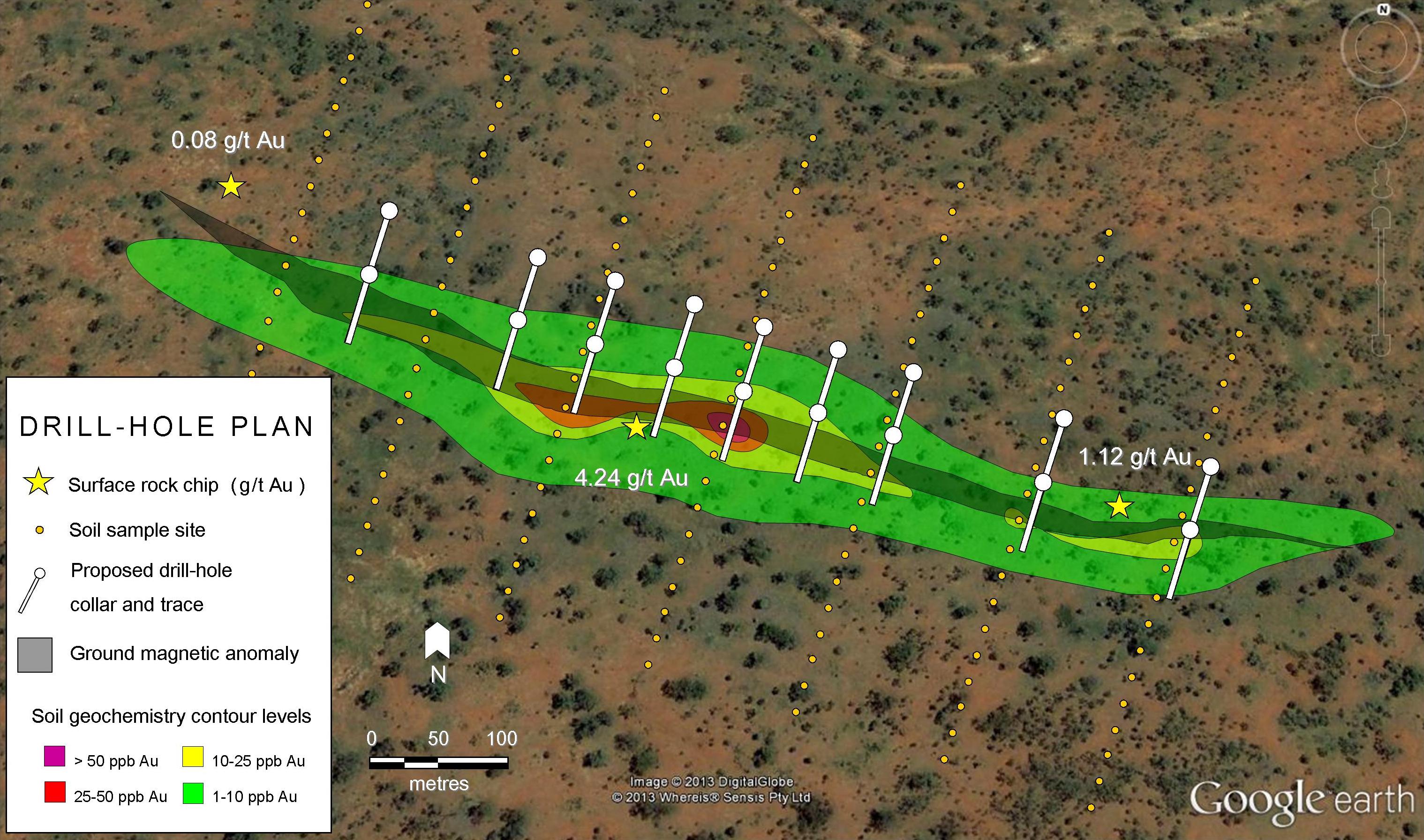
Prioritizing anomalies can be a balancing act between deciding on good targets that are small and large targets that do not have much geochemical or geophysical data support. The image below shows an example of a mineral train map published by Stornoway Diamonds: the black arrow indicates the ice direction (as the glacier is advancing/forming); ground geophysical surveys placed at the head of each mineral train would be used to look for magnetic anomalies suitable for drilling. If no targets are recognized in the data, the sampling process may be extended to confirm the mineral train. Furthermore, alternate geophysical methods (e.g. electromagnetic or gravity surveys) may be used to help the interpretation. In some cases, if the overburden layer is not very thick, it may be possible to find outcropping kimberlite (i.e. kimberlite rock exposed at the surface) at the site of a geophysical anomaly. Geophysical inverse modeling of anomalies is common in order to estimate the depth of targets prior to drilling.
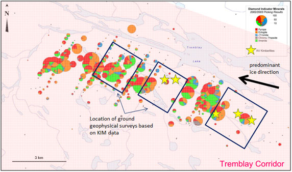
Modified from Stornoway Diamonds presentation “Diamond Exploration: A Multi-stage Process“
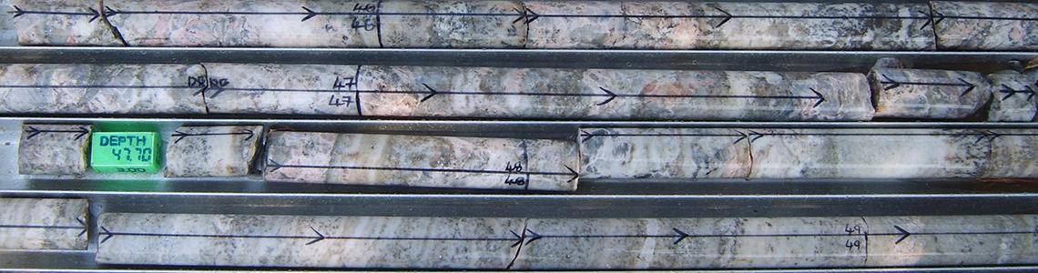
The two main methods for drill testing kimberlite anomalies are core-drilling and reverse-circulation (RC) drilling. Core drilling is based on a diamond coated drill bit that bores into the rock to provide sections of solid rock. This type of drilling is more expensive than RC drilling but makes geological interpretation easier. RC drilling is based on a perforating mechanism, using a piston-like action known as a “hammer” that drives a tungsten-steel drill bit. Drill cuttings (“chips”) are brought to surface similarly to diamond core drilling. RC drilling is generally based on a more mobile platform. This makes RC drilling useful for testing a large number of targets economically and quickly. However, core drilling is usually the norm for delineating the extents of kimberlites. An angled drill-hole is usually planned across the anomaly in order to test it and obtain an initial sense of its geometry using “pierce points”. These holes are generally from 30 to 250-m deep, with RC holes being on the shallower end.
Stage 3: Evaluation
Following the discovery of a kimberlite pipe, an assessment is made to confirm whether it is related to the associated mineral train; it’s possible there could be more than one source with different mineral chemistries and kimberlites tend to occur in clusters or “fields”. The kimberlite sample is sent for a microdiamond analysis (diamonds smaller than 0.5mm in at least two dimensions) to determine if it is diamondiferous through a process known as caustic fusion. The caustic fusion process is used for processing small samples (<500kg) of kimberlite material. In this process the soft kimberlite rock is dissolved in a strong caustic soda solution leaving only the harder minerals including diamonds. The diamonds are removed using a sieve and sorted based on size. If the kimberlite is sufficiently diamondiferous, based on mircrodiamond analysis, a mini-bulk sample (more drilling) will usually be done to obtain an initial estimate of the grade.
Diamond grades are measured in carats per tonne (cpt), or carats per hundred tonnes (cpht), where one carat is equivalent to 200 milligrams of diamond, or about 0.007 ounces. Positive results from a mini-bulk sample of several hundred tonnes will usually warrant the commencement of a larger bulk sample, using large diameter drilling and trenching. A bulk sample consists of several thousand tonnes and provides a better assessment of grade. The bulk sample is processed using a procedure known as dense media separation (DMS) that separates the heavy minerals from lighter ones. The concentrate of dense minerals is then further processed to get a diamond count. This information is used to calculate tonnage potential for a possible mine. An independent market valuation of the diamonds from the bulk sample is used together with the tonnage and grade information to build a preliminary revenue model (i.e. Tonnage x Grade x Value). This is followed by a National Instrument (NI) 43-101 compliant technical report identifying the resource. Further kimberlite pipe delineation drilling is usually done to constrain the geometry of the pipe from the surface down to a zone between 300-400 metres in depth.
Throughout the exploration and evaluation stages, there are parallel processes aimed at generating awareness of the project and soliciting feedback from stakeholders (e.g. nearby communities). The process of collecting data for environmental baselines is usually established early by exploration companies and environmental studies are undertaken throughout the exploration stages.
Mining licenses and permitting follow after government review of completed feasibility, environment, and socio-economic studies.
This is a brief summary of the exploration stages involved in the discovery of a diamond deposit in glaciated terrains, and particularly in Canada. Many details have been left out for the sake of brevity. In a future write-up, we will cover specific geophysical methods used in kimberlite exploration.
Pingback: Geophysical Survey Methods in Diamond Exploration | Geology for Investors