Black Widow Resources is currently trading at $0.065, close to the half way mark when it was listed a little over a year ago at $0.15. Lead by an experienced exploration team, it should be interesting to see how this new company develops.
[box type=”info” align=”aligncenter” ]Disclaimer: This is an editorial review of a public press release and not an endorsement. It may include opinions or points of view that may not be shared by the companies mentioned in the release. The editorial comments are highlighted so as to be easily separated from the release text and portions of the release not affecting this review may be deleted. [/box]
TORONTO, ONTARIO–(Marketwired – June 12, 2014) – Black Widow Resources Inc. (“Black Widow” or the “Company”) (TSX VENTURE:BWR) is pleased to announce that it has intersected massive sulphide mineralization in each of six holes that were completed during a recent diamond – drilling program on its Shunsby Property (the “Property”), accentuated by hole BWR-14-03 that intersected 35.5 meters averaging 2.4% Zinc, including 6.2 meters that averaged 6.1% Zinc. Significant mineralized intercepts were received for each of the six holes, the highlights for which are as follows:
[box type=”note” align=”aligncenter” ]Black Widow Resources is a junior exploration company currently operating in Ontario, Canada. The company, which began trading on the TSX (TSX: BWR) in April of 2013, is born of it’s more well known predecessor “Spider Resources”. For those of you that aren’t familiar with the name, Spider Resources was the first to discover northern Ontario’s “Ring of Fire” chromite deposit. The team from Spider Resources was quick to get back into the exploration game after the company was purchased by Cliff’s Natural Resources in 2010 and their new company is involved in three properties; the Gremlin Prospect, the Santa Maria and the Shunsby Property. This release is from their latest drill program on the Shunsby property.
The Shunsby property is a volcanogenic massive sulfide deposit (VMS) located 190km from Sudbury and has been actively explored since the early 1900’s. In October 2013, Black Widow Resources filed a 43-101 compliant technical report to assess the technical and economic potential within the property and develop a follow up exploration program based on their interpretations of historical work. Diamond drilling for this year was designed to confirm data from exploration activities from the early eighties. The drill program also included holes completed in the late fifties and sixties by Shunsby Mines and Tech Exploration.[/box]
| Hole ID | Mineralized Zone | From (m) | To (m) | Interval (m) | Copper (%) | Zinc (%) | Lead (%) | Silver (g/t) |
| BWR-14-01 | A | 44.7 | 48.1 | 3.5 | 0.14 | 2.07 | 0.45 | 2.5 |
| B | 53.0 | 58.3 | 5.3 | 0.08 | 1.86 | 0.48 | 1.88 | |
| BWR-14-02 | A | 4.1 | 22.0 | 17.9 | 1.06 | 2.15 | 0.56 | 9.95 |
| including | 10.5 | 16.5 | 6.0 | 1.49 | 3.24 | 0.92 | 5.48 | |
| B | 30.0 | 36.0 | 6.0 | 0.86 | 1.41 | 0.02 | 2.45 | |
| BWR-14-03 | A | 10.5 | 46.0 | 35.5 | 0.06 | 2.37 | 0.22 | 1.4 |
| including | 24.0 | 30.2 | 6.2 | 0.06 | 6.07 | 0.21 | 1.77 | |
| B | 96.2 | 99.5 | 3.3 | 0.32 | 2.18 | 0.3 | 7.06 | |
| C | 116.4 | 121.7 | 5.3 | 1.37 | 3.38 | 0.23 | 4.5 | |
| BWR-14-04 | A | 10.0 | 40.7 | 30.7 | 0.29 | 2.81 | 0.31 | 2.71 |
| including | 22.2 | 28.5 | 6.3 | 0.07 | 5.31 | 0.54 | 2.73 | |
| B | 91.2 | 100.2 | 9.0 | 0.29 | 2.11 | 0.31 | 2.3 | |
| C | 105.0 | 110.0 | 5.0 | 0.73 | 0.95 | 0.02 | 2.2 | |
| BWR-14-05 | A | 94.5 | 97.8 | 3.3 | 0.29 | 0.97 | 0.08 | 6.9 |
| B | 104.0 | 108.0 | 4.0 | 0.12 | 0.98 | 0.19 | 0.9 | |
| C | 115.5 | 121.7 | 6.2 | 1.51 | 1.61 | 0.17 | 3.4 | |
| BWR-14-06 | A | 72.0 | 75.5 | 3.5 | 0.03 | 0.82 | 0.13 | 0.85 |
| B | 85.3 | 87.5 | 2.2 | 0.14 | 3.19 | 0.74 | 1.71 |
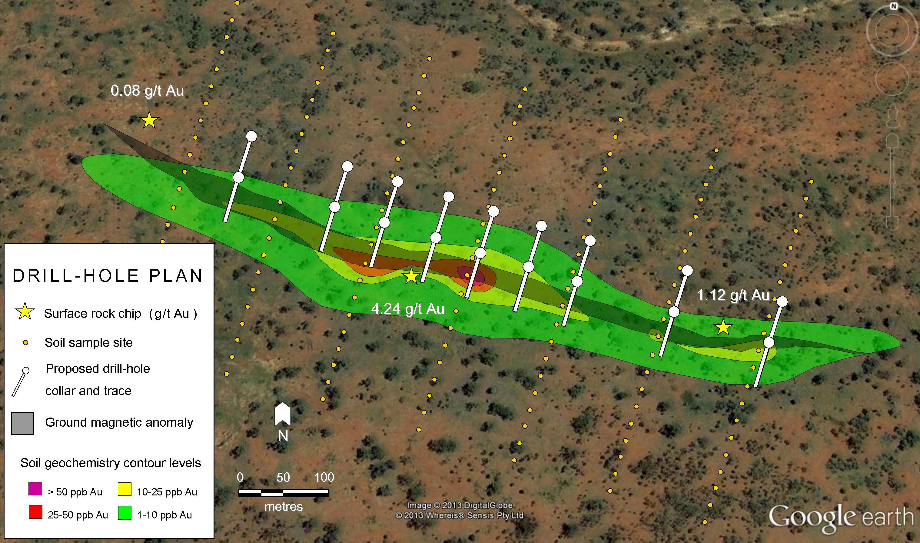
The Shunsby Property consists of 20 contiguous crown patent claims (“patents”) comprising 314.43 hectares of mineral and surface rights, located in central Cunningham Township, southwest of Timmins, and northwest of Sudbury. BWR’s initial diamond drilling was completed under the supervision of James Burns, P.Eng. a registered geological engineer in the Province of Ontario, now residing in Shediac, New Brunswick.
“The recent program was designed to confirm subsurface zinc and copper mineralization, spaced out over a strike length of approximately 400 meters. This central zone of mineralization forms part of a much larger zone that was previously defined by historical drill holes along with surface trenching dating back to the early 1950’s. The confirmatory program was successful, mineralization was encountered in each hole, very reminiscent of what earlier explorers working on the project encountered. The results of the program that consisted of twinning only six holes was not conclusive in each case, the historical data will be used with guarded confidence for future exploration work.”
– Mr. Neil Novak, President and CEO of Black Widow Resources Inc.
[box type=”note” align=”aligncenter” ]
Mineral properties may change hands for a variety of reasons. Volatile commodity prices, the cost of continued exploration, bankruptcy, or a simple desire to follow the next hot project may cause a company to drop a project from its portfolio. This change of hands can sometimes lead to data loss; such as locations of drill holes, drill logs, or even drill core. With modern advances in assay analysis, companies that acquire new properties generally re-sample historical drill core to confirm previously reported results. Drill core may be lost or may deteriorate if poorly stored, leaving new owners with old reports, but no rocks. If a few fresh drill holes can confirm previous results, geologist can more confidently refer to old reports.
[/box]
Hole BWR-14-01 was setup within a few meters (as per GPS readings) of historical hole 81-08 drilled as part of a Placer Exploration program in 1981 at -80 degrees, at an azimuth of 190 degrees to a total depth of 69 meters. No evidence of hole 81-08 was observed, due to deep snow cover at the time of drilling. Available records for hole 81-08 indicate that a mineralized zone was encountered between 51.8 meters and 63.4 meters that when assayed averaged 1.6% copper and 4.7% zinc for a mineralized zone of 11.6 meters. BWR’s hole 14-01 intersected mineralization commencing at 44.7 meters and continuing intermittently until 58.3 meters for a mineralized intercept of 13.6 meters. The recent hole returned much lower copper values, with zinc values moderately correlating with the earlier results.
Hole BWR-14-02 was setup in close proximity (according to GPS measurements) to historical hole 81-01 was also drilled as part of a Placer Exploration program in 1981 vertically to a total depth of 41 meters. Little evidence of hole 81-01 was observed, other than what appeared to be a flat perhaps old drill area. Old drill rods were found nearby once the snow melted. Records indicate that hole 81-01 intersected a mineralized zone between 26.4 meters and 36.4 meters that averaged 2.5% copper and 0.9% zinc for a mineralized zone of 10 meters. BWR’s hole 14-02 intersected a much wider mineralized zone commencing at 4.1 meters and continuing intermittently until 36.0 meters for a mineralized intercept of 31.9 meters. The recent hole had very comparable copper values with moderately higher zinc values, as such supporting and correlating well with the earlier results.
Hole BWR-14-03 was setup within a few meters (as per GPS measurements) of historical hole 56-57 drilled by Shunsby Mines Ltd., as part of an earn-in option where Teck Exploration took control of the project later in 1956. As a confirmation of past drilling, an old drill rod that was used to mark the historical hole was observed. Available records indicate that Hole 56-57 was drilled vertically to a total depth of 164 meters, intersecting a mineralized zone between 27.1 meters and 52.1 meters that averaged 0.1% copper and 3.3% zinc for a mineralized zone of 25 meters. BWR’s hole 14-03 intersected a much wider mineralized zone commencing at 10.5 meters and continuing intermittently until 46.0 meters for a mineralized intercept of 35.5 meters. The recent hole had very comparable copper and zinc values, strongly supporting the earlier results.
Hole BWR-14-04 was setup a few meters away (according to GPS readings) from historical hole 56-62 initially drilled as part of an option earn-in by Teck Exploration in 1956. The original hole was drilled to 65 meters (by Teck) with an initial dip of 45 degrees at an azimuth of 067 degrees. The historical hole was later extended to a total depth of 132 meters, under the direction of Franc Joubin in 1966 as he was grooming the property for Consolidated Shunsby Mines Ltd. During the course of drilling hole BWR 14-04, the original casing for hole 56-62 was found 3 meters east of the selected site for BWR 14-04. According to available records, the historical hole(s) intersected three mineralized zones, the first of which was between 31.1 meters and 47.9 meters that averaged 0.03% copper and 4.2% zinc for a mineralized zone of 16.8 meters, followed by a second mineralized zone between 90 meters and 93.3 meters that averaged 0.5% copper and 4.6% zinc for a mineralized zone of 3.3 meters, followed by a third mineralized zone between 96.9 meters and 113.9 meters that average 0.98% copper and 2.3% zinc over a drill intercept of 17.0 meters. BWR’s hole 14-04 intersected three mineralized zones as well, commencing at 10 meters and continuing intermittently through to 110.0 meters down-hole, for a mineralized zone of 100 meters. The recent hole assay results are distributed very similarly and are very comparable in grade for both copper and zinc values, thus strongly supporting the earlier results.
Hole BWR-14-05 was setup within a few meters (according to GPS readings) of historical hole 68-06 which was drilled by Consolidated Shunsby Mines Ltd. in 1968 vertically to total depth 177 meters. Evidence of historical drilling consisting of old drill rods, was found during the setup of the BWR hole. According to available drill logs, the historical hole intersected a mineralized zone between 81.7 meters and 89.3 meters that averaged 0.06% copper and 5.4% zinc for a mineralized zone of 7.6 meters. BWR’s hole intersected three mineralized zones between 94.5 meters and continuing in and out of mineralization through to 121.7 meters down-hole, for a moderately mineralized zone of 27.2 meters. The recent hole assay results are not very comparable in distribution down hole and the grade for copper is higher in the recent hole while the grade for zinc values is somewhat less, poorly supporting the earlier results.
Hole BWR-14-06 was setup within a few meters of historical hole 68-16 which was drilled by Consolidated Shunsby Mines Ltd. in 1968 vertically to 141 meters. No evidence of historical drilling was observed. According to available records the historical hole intersected a mineralized zone between 115.8 meters and 121.8 meters that averaged 2.1% copper and 3.1% zinc for a mineralized zone of 6.0 meters. BWR’s hole intersected two mineralized zones between 72.0 meters going in and out of mineralization through to 87.5 meters down-hole, for a moderately mineralized zone of 15.5 meters. The assay results from the recent hole are comparable in distribution down hole, however the grade for copper is much lower in the recent hole while the grade for zinc is more or less comparable, partially supporting the earlier results.
[box type=”note” align=”aligncenter” ]
Although the results are consistent with massive sulfide mineralization, the copper values don’t appear to match with what was drilled in the past. One possible reason may be how the assay results were reported in the past. Prior to regulations implemented by the Canadian Securities Commission on assay reporting, results didn’t require standards and were reported “as is”. Proper QA/QC procedures not only ensure accuracy in individual assay results but also to ensure that a lab is producing accurate results overall and avoiding cross contamination between samples. [/box]
Discussion of Results
As explained in earlier press releases, (May 14, 2014 and October 15, 2013) the historical drilling by different operators is best summarized in the Shunsby Report that is on file with sedar and available on Black Widow’s website: www.blackwidowresources.com. Historical drilling consisted of 214 drill holes drilled on the property between 1954 and 1993. The logging and visual observations of mineralized intercepts of the current holes were reported to be fairly consistent with the results of historical drilling. The samples selected and assays received have verified that zinc and copper is present in potentially commercial grades on the Shunsby property, however the tenure of mineralization and consistency of reproducible results (historic vs. current) is somewhat tenuous to confirm. Geological observations suggest a very long lived subaqueous volcanogenic event, with numerous episodes of explosive activity followed by periods of quiescence and accumulation of zinc, copper, lead and iron sulphide mineralization. This complex geology may partially account for the variances noted in the comparisons, so it is felt by management that the historical results can be used confidently as a guarded guide in locating and planning to identify areas of mineralization.
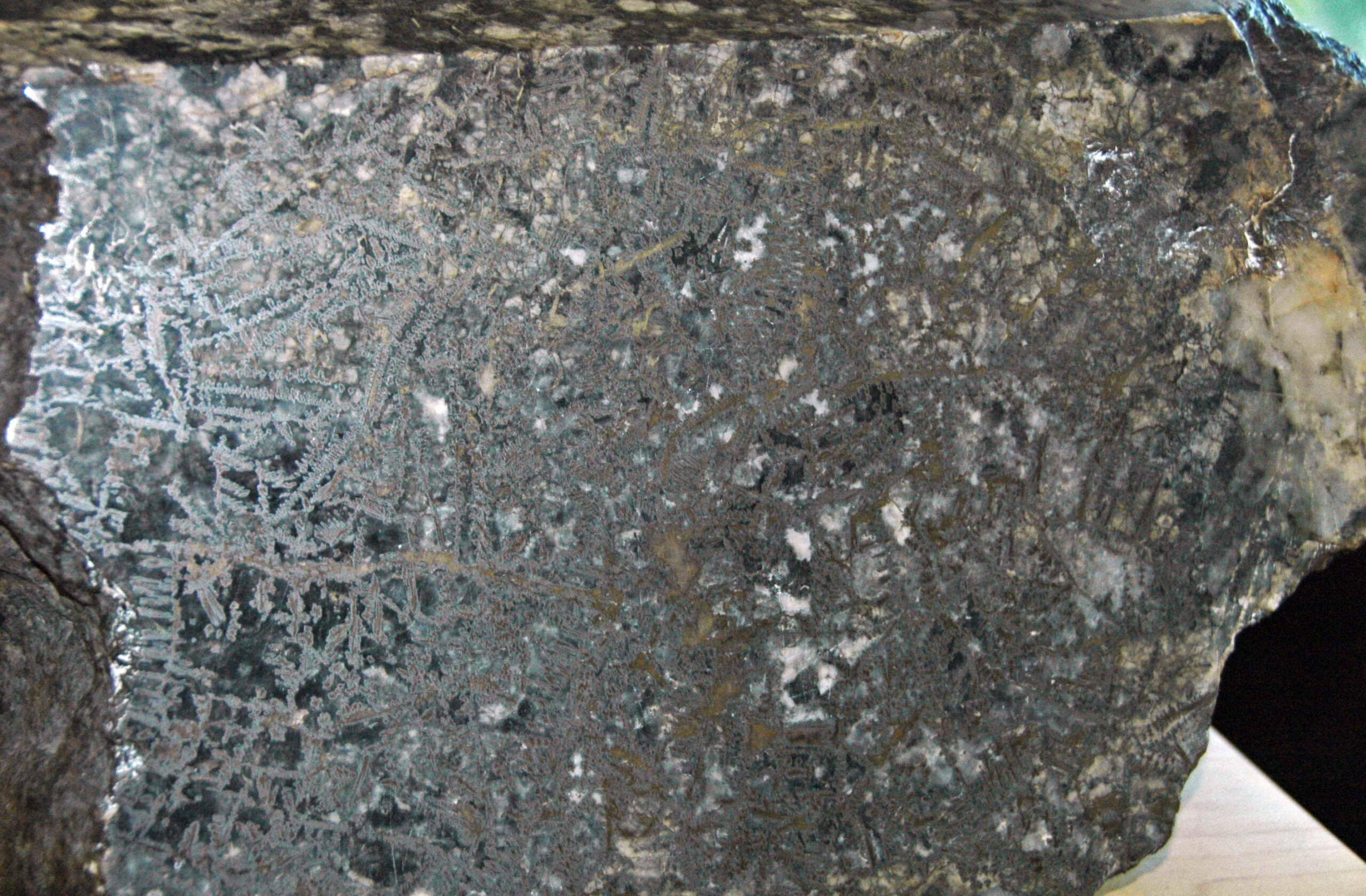
[box type=”note” align=”aligncenter” ]VMS deposits form around volcanoes in deep marine settings (“black smokers). Sulfides within these deposits can form zones of chalcopyrite (copper sulfide) as the core, surrounded by sphalerite (zinc sulfide) and then galena (lead sulfide). While Black Widow’s recent drill results contain trace amounts of copper, the mineralization is dominantly zinc and lead. This, along with some of the historical copper values, may suggest that they are on the periphery of a VMS system, and further targeted drilling may bring them closer to the original source. [/box]
The Company is currently reviewing the new drill results (lithogeochemical review) along with the plethora of historical data as needed to plan its’ follow-up exploration program that may include: additional diamond drilling, surface trenching, property bedrock sampling, ground survey line establishment, and geophysical test surveys (gravity and/or IP surveying).
[box type=”note” align=”aligncenter” ]The company will be spending time analyzing the geochemistry of the samples collected (lithogeochemical review). Exploration geologists can use the chemistry to draw comparisons between the rocks throughout a property. This can help determine which rocks are associated with mineralization (and which are not). The company also plans to advance exploration through surface sampling , trenching and bedrock sampling. Geophysical methods such as gravity surveying can help identify density anomalies with the earth’s surface. Since VMS deposits are composed of large metallic bodies they would have a prominent gravity signature compared to the surrounding rock. An Induced Polarization (IP) survey may also be useful in identifying deep zones of “chargeable” rock which can indicate the presence of metal ores. [/box]
Analytical Procedures
All samples from this program were submitted to Actlabs’ facility in Sudbury for assaying initially using sample preparation code RX1 (crush sample so that 90% passes 2mm screen, split 250g that is pulverized so that 95% passes 105 micron) followed by multi-element analysis using UT-5 Total Digestion (Ultratrace 5 is a combination of INAA with a 4-acid digestion ICP/MS. Some of the resistate elements are provided by INAA. All samples that assayed over-limits for Cu, Zn and Pb from UT-5 TD were re-analyzed as needed using 8 Peroxide ICP analysis (Sodium peroxide fusion, acid dissolution followed by ICP/OES). Actlabs is accredited by the Standards Council of Canada (“SCC”) International Standards Organization / International Electrotechnical Council (“ISO/IEC 17025”).
[box type=”note” align=”aligncenter” ]The samples were analysed using a “total digestion” method, through the use of strong acids such as perchloric, hydrofluoric, hydrochloric and nitric acid to completely dissolve the rock sample. Some minerals can be resistive to the digestion process and these samples require further analysis with the use of INAA (Instrumental Neutron Activation Analysis). This type of analysis involves the sample being bombarded by radiation within a specially designed nuclear reactor. The resulting gamma ray signature that can be used for identification. [/box]
Qualified Persons
Mr. James G. Burns, P.Eng. was the onsite Qualified Person, overseeing the drill program. Mr. Burns reported directly to Mr. Neil Novak, P.Geo., President of Black Widow Resources Inc.. Both are registered as Qualified Person (“QP”) in the Province of Ontario, as defined by National Instrument 43-101 Standards of Disclosure for Mineral Projects (“NI 43-101”) and Form 43-101F1 Technical Report and Related Consequential Amendments, Messrs. Novak and Burns have reviewed and approved the technical content of this press release.
[box type=”note” align=”aligncenter” ]Black Widow Resources is currently trading at $0.065, close to the half way mark when it was listed a little over a year ago at $0.15. Lead by an experienced exploration team, it should be interesting to see how this new company develops. [/box]
About Black Widow Resources
Black Widow is a public company, quoted for trading on the TSX.V under the symbol “BWR”, with exploration projects in Northern Ontario, Canada, focused on exploring for base and precious metals. Management of Black Widow includes an accomplished group of exploration/mining specialists with many decades of operational experience in the junior resource sector. There are currently 24,264,769 shares issued in Black Widow.
[box type=”success” align=”aligncenter” ]Have a company or release you’d like us to look at? Let us know though our contact page, through Google+, Twitter or Facebook.[/box]