Although Virginia Mine’s is protecting their investment by providing geological support, both companies will benefit from this synergistic approach – shared expertise, a common cause and hopefully an advancing project.
YELLOWKNIFE, NORTHWEST TERRITORIES–(Marketwired – June 17, 2014) – TerraX Minerals Inc. (TSX VENTURE:TXR)(FRANKFURT:TX0)(PINKSHEETS:TRXXF) has commenced summer field exploration programs on its wholly-owned Yellowknife City Gold Project (“YCGP”) in the Northwest Territories. Work over the coming weeks will include mapping and prospecting and surveying over the contiguous Northbelt, Walsh Lake, U-Breccia and Ryan Lake properties that make up the approximately 8,400 hectare YCGP, with drilling to resume later this month when the water levels from spring breakup recede. This spring has been particularly dry, and technical crews are now onsite assessing ground conditions for a possible early start-up of summer drilling.
[box type=”note” align=”aligncenter” ] The Yellowknife City Gold project is TerraX’s flagship project in the Northwest Territories. When we last talked about TerraX they were re-sampling historical drill core from their Crestaurum property (part of the YCGP). This year TerraX is planning a fairly extensive surface exploration program across some of it’s properties within the Yellowknife city gold project.
Seasonal variations can complicate exploration programs in the far north. Exploration activities throughout the year can peak or wane. During the late spring as snow melts, geologists can begin field mapping and collecting samples. However when it comes to drill programs, rain fall, along with melting snow can create over saturated conditions making it difficult for heavy machinery to move drill rigs. Also, surprise snow storms during this time can also delay drilling. Depending on which latitude you are on, temperatures and availability of water can affect the length of time a drill can operate. In the far north drill programs usually begin the beginning of March and are completed towards the end of September. TerraX is taking the first steps in ensuring it can have an early swing on this year’s drilling. [/box]
Summer surface work will cover multiple high value target areas on the YCGP. A concerted mapping and prospecting effort will be made on the Walsh Lake property following up positive results from surface sampling completed by TerraX in 2013, over only a two day period, that included chip sampling of 6m @ 7.29 g/t Au at the Mispickel Island showing, and 4m @ 6.20 g/t Au on the Samex showing (news release of Oct 30, 2013). On Northbelt work will continue to follow up on zones discovered by TerraX during 2013 field work including the Crestaurum Southwest Zone (chip sampling of 4.0m @ 24.26 g/t Au reported Nov. 6, 2013), and the Pinto Shear (grab sample of 49.3 g/t Au reported July 3, 2013). TerraX will also be conducting initial exploration along projected extensions of areas previously mined by Giant Mines along the southern boundary of the property (Lynx, GBK, C-Zone).
[box type=”note” align=”aligncenter” ]The early stages of exploration can be fairly inexpensive, relatively speaking. Before moving any drill rigs onto a property, proper mapping and rock sampling by a determined geologist with a rock hammer can help build a base of geologic knowledge to help guide future work. [/box]
While gold targeting will be our prime focus, Virginia Mines Inc. has offered to provide senior geologists to assist in following-up on VMS style mineralization encountered in TerraX’s surface sampling in 2013 (chip sample of 5.00m @ 1.54m g/t Au, 95.5 g/t Ag, 3.13% Pb, 1.59% Zn reported July 3, 2013). This result was followed up by drilling in April of 2014 that intercepted a pervasively mineralized felsic volcanic with71.15m @ 0.25 g/t Au, 14.0 g/t Ag, 0.73% Pb and 0.57% Zn in hole TNB14-004 (inclusive of 3.42m @ 3.41 g/t Au, 69.3 g/t Ag, 3.67% Pb, 3.17% Zn) reported on May 12, 2014. Mapping and prospecting will be directed at establishing the controls on this mineralization for follow-up drilling in 2015.
[box type=”note” align=”aligncenter” ]We have previously talked about Virginia Mines which holds a 9.8% interest in TerraX. Virginia Mines is offering TerraX their assistance and expertise on Volcanogenic Massive Sulfide (VMS) deposits. This could help further TerraX’s understanding of the prospect. [/box]
As well TerraX has contracted for a LIDAR survey (Light Detection and Ranging) to be carried out in June 2014 over the entire YCGP. This survey will provide detailed elevation data of bare earth and vegetated terrain models, as well as a high resolution airphoto mosaic. This information will allow TerraX to trace mineralized shear zones (locally topographic lows); provide surface modelling for future NI 43-101 mineral resource estimation; and be an invaluable tool for detailed collar location planning for exploration and definition drill programs.
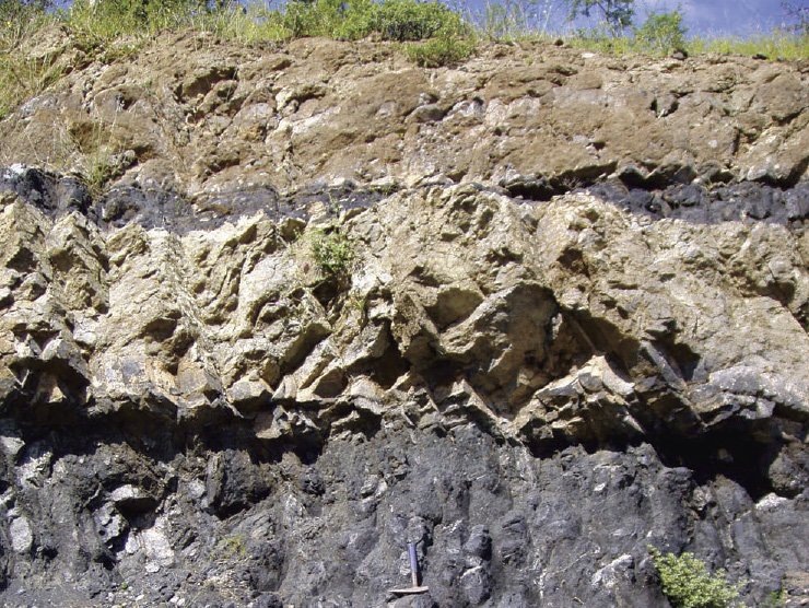
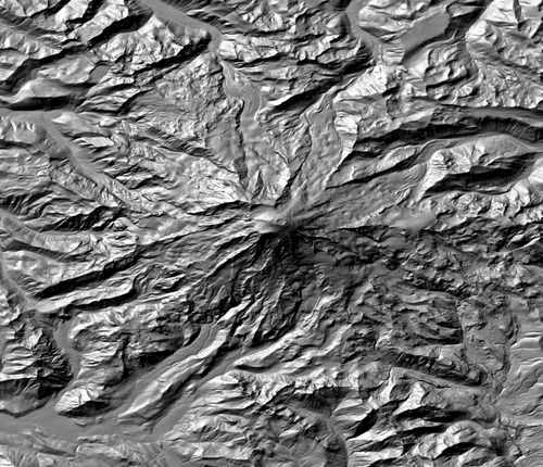
[box type=”note” align=”aligncenter” ]LIDAR is a near surface survey technique using light to map out the topography of an area. A laser is fired from either a satellite or aircraft and a recorder measures the amount of time it takes for the laser to travel back to the transmitter. Due to the thickness of the beam (600 to 1000 nano meters), it can create very high resolution maps of the surface topography, known as a digital elevation model (DEM). Geologists and geophysicists use this information to identify potential structures at the surface. We posted an example (not from this area) of a DEM below.[/box]
The technical information contained in this news release has been approved by Joseph Campbell, the President of TerraX, who is a Qualified Person as defined in “National Instrument 43-101, Standards of Disclosure for Mineral Projects.”
About the Yellowknife City Gold Project
The Yellowknife City Gold Project encompasses approximately 8,400 hectares of contiguous land immediately north of the City of Yellowknife in the Northwest Territories and includes TerraX’s wholly-owned Northbelt property acquired in February 2013.
The Northbelt gold property encompasses 3,562 hectares on the prolific Yellowknife belt, all within 15 km of the city of Yellowknife, and covers 13 km of strike on the northern extension of the geology that contained the past producing high-grade Giant and Con gold mines. The Northbelt property is host to multiple shears that are the recognized hosts for gold deposits in the Yellowknife camp and it contains innumerable gold showings and historic high grade drill results.
TerraX has carried out a strategy of acquiring prospective ground adjacent to Northbelt and in October 2013 entered into an option agreement whereby it can acquire a 100% interest in the Walsh Lake gold property, which is contiguous with and immediately east of Northbelt. The Walsh Lake property consists of seven leases and five claims totaling 6,659 acres (2,695 hectares). TerraX has also staked and acquired ground to the west of Northbelt to cover prospective geology that is on strike from Northbelt structures.
[box type=”note” align=”aligncenter” ]Terra X is currently trading at $0.47, halfway from it’s 52-week high of $0.90. Although Virginia Mine’s is protecting their investment by providing geological support, both companies will benefit from this synergistic approach – shared expertise, a common cause and hopefully an advancing project. [/box]
[box type=”success” align=”aligncenter” ]Have a company or release you’d like us to look at? Let us know though our contact page, through Google+, Twitter or Facebook.[/box]
Subscribe for Email Updates